Approximate Location Map
Large Map »
Latitude: 53.0171 / 53°1'1"N
Longitude: -1.7331 / 1°43'59"W
OS Eastings: 417999
OS Northings: 346673
OS Grid: SK179466
Mapcode National: GBR 48Q.SRM
Mapcode Global: WHCF5.BFYD
Plus Code: 9C5W2788+RP
Entry Name: Barclays Bank
Listing Date: 6 May 1970
Grade: II
Source: Historic England
Source ID: 1109497
English Heritage Legacy ID: 79908
ID on this website: 101109497
Location: Ashbourne, Derbyshire Dales, Derbyshire, DE6
County: Derbyshire
District: Derbyshire Dales
Civil Parish: Ashbourne
Built-Up Area: Ashbourne
Traditional County: Derbyshire
Lieutenancy Area (Ceremonial County): Derbyshire
Church of England Parish: Ashbourne St Oswald
Church of England Diocese: Derby
Tagged with: Bank building
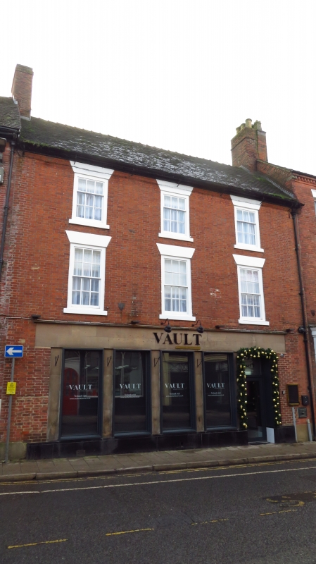
ST JOHN'S STREET
1.
783
(South-East Side)
No 8 (Barclays Bank)
SK 14 NE 1/34 6.5.70.
II GV
2.
C18. Continuous with above. Moulded eaves cornice and old tiled roof. 3 storeys,
3 windows with plain lintels and sills, sashes with glazing bars. Modern treatment
to bank on ground floor.
No 2 and Nos 6 to 44 (even) form a group.
Listing NGR: SK1799946673
External links are from the relevant listing authority and, where applicable, Wikidata. Wikidata IDs may be related buildings as well as this specific building. If you want to add or update a link, you will need to do so by editing the Wikidata entry.


Other nearby listed buildings
