Approximate Location Map
Large Map »
Latitude: 50.9258 / 50°55'32"N
Longitude: -2.3052 / 2°18'18"W
OS Eastings: 378648
OS Northings: 114084
OS Grid: ST786140
Mapcode National: GBR 0X0.S1W
Mapcode Global: FRA 661N.KRT
Plus Code: 9C2VWMGV+8W
Entry Name: Market Cross
Listing Date: 4 October 1960
Grade: II
Source: Historic England
Source ID: 1110546
English Heritage Legacy ID: 102441
ID on this website: 101110546
Location: Sturminster Newton, Dorset, DT10
County: Dorset
Civil Parish: Sturminster Newton
Built-Up Area: Sturminster Newton
Traditional County: Dorset
Lieutenancy Area (Ceremonial County): Dorset
Church of England Parish: Sturminster Newton St Mary
Church of England Diocese: Salisbury
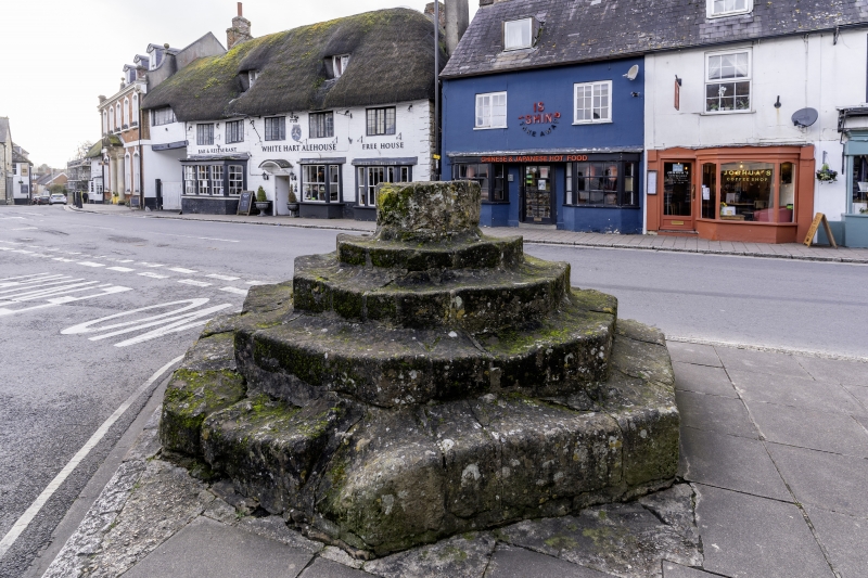
ST 7814 STURMINSTER NEWTON
MARKET CROSS (EAST SIDE)
8/153 Market Cross
4.10.60
G.V. II
Base and pedestal of a market cross, probably C15. Octagonal base of 4 stone
steps with an octagonal pedestal. Scheduled as an ancient monument. "RCHM,
Dorset, Vol III", HMSO, 1970, p 271, no 2.
Listing NGR: ST7864914084
External links are from the relevant listing authority and, where applicable, Wikidata. Wikidata IDs may be related buildings as well as this specific building. If you want to add or update a link, you will need to do so by editing the Wikidata entry.


Other nearby listed buildings
