Approximate Location Map
Large Map »
Latitude: 50.3655 / 50°21'55"N
Longitude: -4.1437 / 4°8'37"W
OS Eastings: 247634
OS Northings: 53924
OS Grid: SX476539
Mapcode National: GBR RB2.ZW
Mapcode Global: FRA 2862.HHY
Plus Code: 9C2Q9V84+5G
Entry Name: Gate Piers at South End of Street
Listing Date: 9 November 1998
Grade: II
Source: Historic England
Source ID: 1113344
English Heritage Legacy ID: 473566
ID on this website: 101113344
Location: West Hoe, Plymouth, Devon, PL1
County: City of Plymouth
Electoral Ward/Division: St Peter and the Waterfront
Parish: Non Civil Parish
Built-Up Area: Plymouth
Traditional County: Devon
Lieutenancy Area (Ceremonial County): Devon
Tagged with: Gatepost
PLYMOUTH
SX4753 LOCKYER STREET, Hoe
740-1/66/289 (South side)
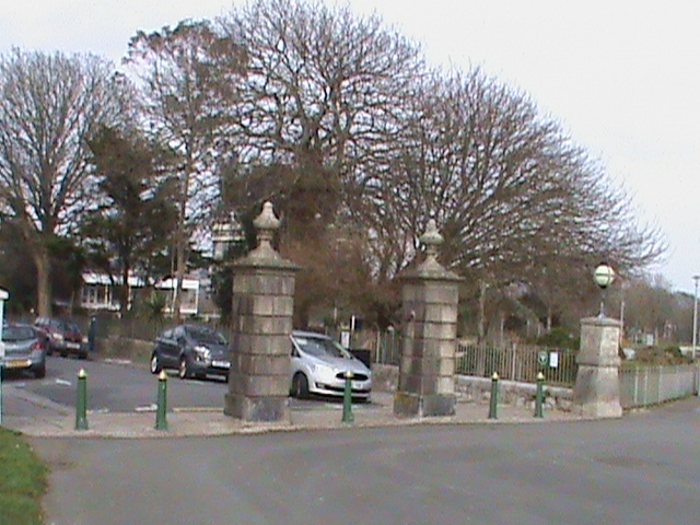
Gate-piers at south end of street
GV II
Gate-piers at end of planned street. Mid C19. Pair of
square-on-plan rusticated granite ashlar gate-piers with
plinths and moulded cornices surmounted by turned finials.
Part of an important planned group of terraces and villas.
Included for group value.
Listing NGR: SX4763453924
External links are from the relevant listing authority and, where applicable, Wikidata. Wikidata IDs may be related buildings as well as this specific building. If you want to add or update a link, you will need to do so by editing the Wikidata entry.


Other nearby listed buildings
