Latitude: 51.4517 / 51°27'5"N
Longitude: -0.9673 / 0°58'2"W
OS Eastings: 471852
OS Northings: 173024
OS Grid: SU718730
Mapcode National: GBR QMH.S2
Mapcode Global: VHDWT.5SY1
Plus Code: 9C3XF22M+M3
Entry Name: 77 and 79 London Street
Listing Date: 22 March 1957
Last Amended: 11 March 2024
Grade: II
Source: Historic England
Source ID: 1113518
English Heritage Legacy ID: 39033
ID on this website: 101113518
Location: Reading, Berkshire, RG1
County: Reading
Electoral Ward/Division: Katesgrove
Parish: Non Civil Parish
Built-Up Area: Reading
Traditional County: Berkshire
Lieutenancy Area (Ceremonial County): Berkshire
Church of England Parish: Reading St Giles
Church of England Diocese: Oxford
Tagged with: Building
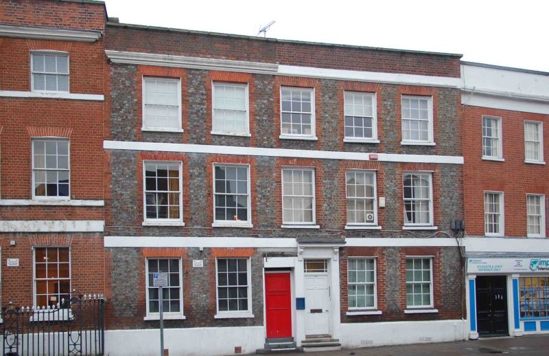
77 and 79 London Street, a pair of substantial mid-C18 houses.
Pair of substantial houses, mid-C18.
MATERIALS: grey brick with red brick and stucco dressings. Number 77 has a hipped plain-tiled roof with two axial valleys, presumably this form was repeated over number 79, which now has a flat roof. No chimney stacks remain.
PLAN: the attached houses face west towards London Street, with number 77 to the north and number 79 to the south.
EXTERIOR: the houses present a symmetrical frontage, five windows wide with paired central entrances. The doorway to number 79 retains what is thought to have been the original door-surround arrangement, with a shallow doorhood on console brackets, and a rectangular fanlight; the details were removed from number 77 at some time after 1943. Number 79 has a six-panelled door; the doorway to number 77 has been boarded up (2022). The windows are of equal size, holding six-over-six sash frames. The openings have red brick jambs and flat arches of gauged brick; one of the ground-floor windows to number 77 has lost one of its red brick jambs. The central windows on the first and second floor are thought to belong to number 79. The house has a stuccoed plinth and platbands between the storeys. There is a moulded cornice to number 77, now simplified to number 79. Above, the parapets to both houses appear to have been rebuilt.
To the rear, number 77 has been obscured at ground-floor level by a later addition; there is irregular fenestration to the floors above. The elevation of number 79 is now completely obscured by later accretions.
The first written record of Reading dates from the ninth century when the name seems to have referred to a tribe, called Reada’s people. It is possible that there was a river port here during the Roman occupation, and by 1086 Reading had grown into a town, recorded in the Domesday Book. The early Anglo-Saxon settlement is believed to have been located in the Castle Street and St Mary’s area, which has St Mary’s Minster at its heart.
After Reading Abbey was founded in 1121, the town grew substantially as a place of pilgrimage as well as an important ecclesiastical and trading centre, with cloth production as the principal industry. Reading’s increasing prosperity saw the establishment of the new Market Place (drawing trade away from the old marketplace at St Mary’s Butts), and of what is today known as London Street, an extension to the High Street, which facilitated trade to and from London. By 1525, Reading had become the largest town in Berkshire. Following its dissolution in 1539, Reading Abbey became a royal palace. The cloth and leather trades continued to flourish and by 1611 the town’s population had grown to over 5,000. John Speed’s map shows that by that year, both sides of London Street had been developed with continuous frontages for a considerable distance southward, beyond the modern junction with Crown Street/London Road. Several buildings which predate Speed’s map survive on London Street, some concealed behind later brick façades.
Following significant upheaval during the Civil War, the town flourished during the C18 and C19. Several developments during this period spurred further growth and prosperity, including the arrival of the Great Western Railway, improvements to the navigability of the River Kennet, and the expansion of the local brewing industry. The survival of many fine Georgian and Victorian buildings along London Street testifies to its prosperity during this period.
77 and 79 London Street were constructed in the mid-C18 as a pair of substantial townhouses. The houses have since undergone a number of external and internal alterations, and both have been extended to the rear. A single-storey extension to the rear of number 77 connects it with an early-C20 hall known as the Olympia Hall, understood now (2022) to be in use as an events venue. Number 77 is understood to have been connected internally with number 75 to the north, which is separately listed at Grade II* (also including number 73; National Heritage List for England entry 1156168). Number 79 is understood to be in multiple occupancy.
77 and 79 London Street, Reading, are listed at Grade II for the following principal reasons:
Architectural interest:
* as a pair of mid-C18 houses which contribute to the character of an architecturally varied historic streetscape.
Historic interest:
* as part of the urban development of Reading’s ancient core.
Group value:
* the buildings are in close proximity to a large number of listed buildings and form part of a strong historic grouping.
External links are from the relevant listing authority and, where applicable, Wikidata. Wikidata IDs may be related buildings as well as this specific building. If you want to add or update a link, you will need to do so by editing the Wikidata entry.
Other nearby listed buildings