Approximate Location Map
Large Map »
Latitude: 52.0083 / 52°0'29"N
Longitude: -0.4257 / 0°25'32"W
OS Eastings: 508154
OS Northings: 235597
OS Grid: TL081355
Mapcode National: GBR G3S.16W
Mapcode Global: VHFQV.KSTB
Plus Code: 9C4X2H5F+8P
Entry Name: Village Lock Up
Listing Date: 10 January 1985
Grade: II
Source: Historic England
Source ID: 1113777
English Heritage Legacy ID: 37687
ID on this website: 101113777
Location: Silsoe, Central Bedfordshire, MK45
County: Central Bedfordshire
Civil Parish: Silsoe
Built-Up Area: Silsoe
Traditional County: Bedfordshire
Lieutenancy Area (Ceremonial County): Bedfordshire
Church of England Parish: Silsoe
Church of England Diocese: St.Albans
Tagged with: Building Village lock-up
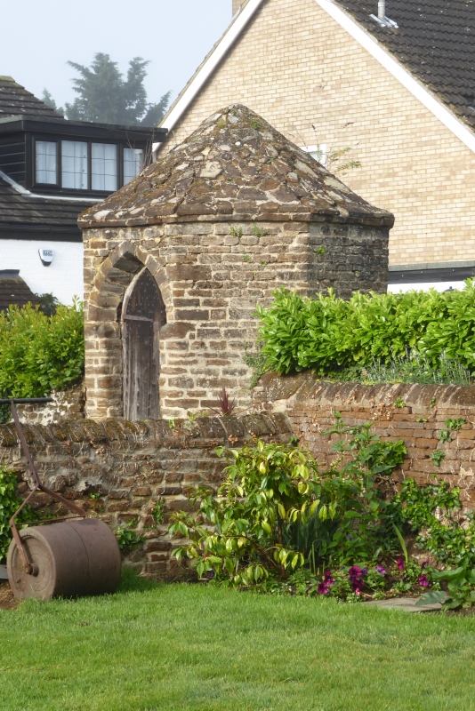
TL 0835 SILSOE CHURCH ROAD
13/132 (South Side)
Village Lock-up
- II
Village lock-up. C20 plaque on door records date 1796. Coursed ironstone.
Cement render over tiled roof. Octagonal plan with conical roof. E elevation
has pointed arched doorway. Pointed arched oak door has strap hinges and
studs.
Listing NGR: TL0815435597
External links are from the relevant listing authority and, where applicable, Wikidata. Wikidata IDs may be related buildings as well as this specific building. If you want to add or update a link, you will need to do so by editing the Wikidata entry.


Other nearby listed buildings
