Latitude: 51.8855 / 51°53'7"N
Longitude: -0.5201 / 0°31'12"W
OS Eastings: 501950
OS Northings: 221811
OS Grid: TL019218
Mapcode National: GBR G50.MBS
Mapcode Global: VHFRC.XVXX
Plus Code: 9C3XVFPH+6X
Entry Name: 19 High Street South
Listing Date: 30 October 1986
Last Amended: 7 February 2023
Grade: II
Source: Historic England
Source ID: 1114603
English Heritage Legacy ID: 35777
ID on this website: 101114603
Location: Dunstable, Central Bedfordshire, LU6
County: Central Bedfordshire
Civil Parish: Dunstable
Built-Up Area: Dunstable
Traditional County: Bedfordshire
Lieutenancy Area (Ceremonial County): Bedfordshire
Church of England Parish: Dunstable
Church of England Diocese: St.Albans
Tagged with: Building
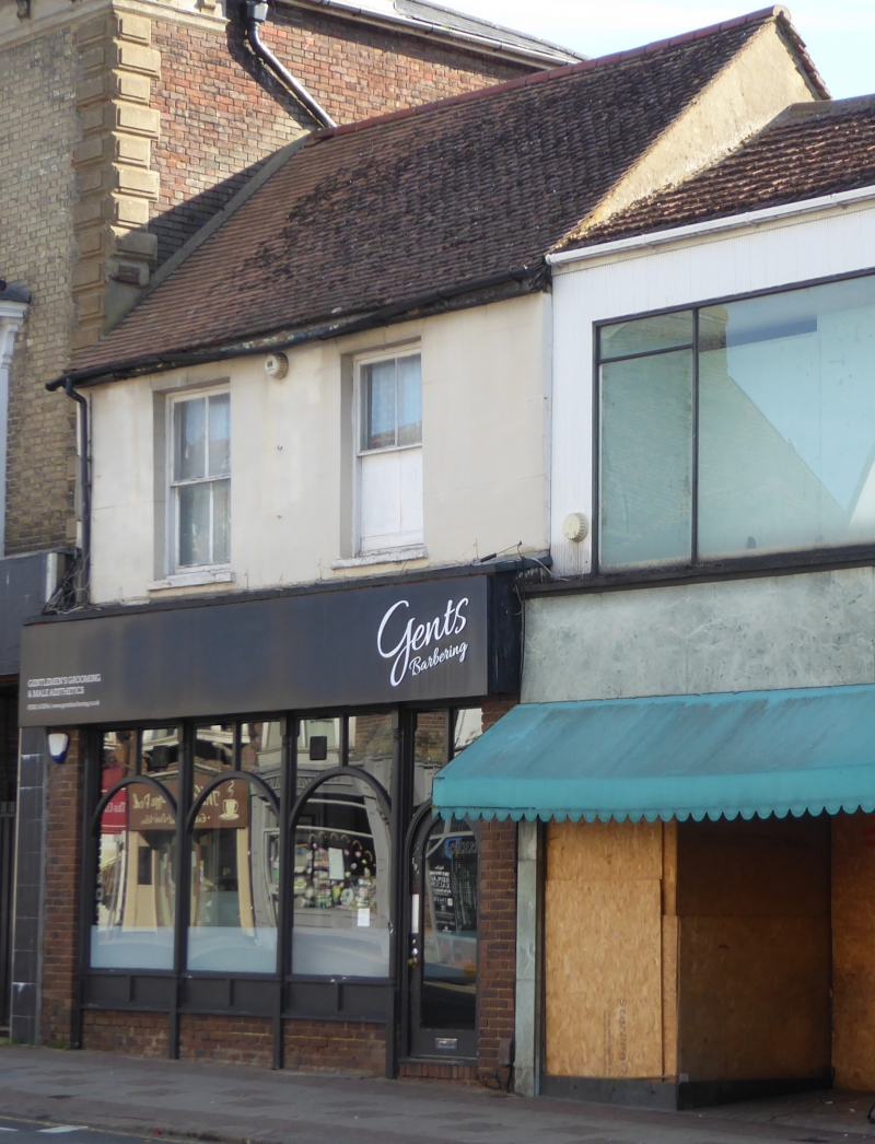
A late-C16 timber-framed building with a C19 and C20 frontage, and rear extensions dated 1825.
A late-C16 timber-framed building with a C19 and C20 frontage, and rear extensions dated 1825. The building has two storeys with a shop front and rear extensions.
MATERIALS: timber-framed with red brick rear extensions and a plain red clay tile roof with some concrete tiles.
PLAN: a rectilinear building on a long, narrow plot.
EXTERIOR: the building has a gabled, tiled roof with the ridge parallel to the street front. The front elevation to High Street South has two sliding sash windows in reveals to the upper storey, which is rendered. The ground floor is red brick laid in stretcher bond, and a shop front dated 1986.
The side elevation has four sliding sash windows at first floor with glazing bars and storey band.
Dunstable town was historically focused upon the intersection of two ancient routes, the Neolithic Icknield Way, running from east to west, and the Roman Watling Street, running from north to south. The crossroad remains a dominant feature in topography of the town. Dunstable has Roman origins, known as Durocobrivis, centred on the crossroads, which appears to have been abandoned at the end of the Roman period. The town was later re-established in the early C12 by Henry I, centred on the royal lodge of Kingsbury and the Augustinian Priory founded in 1131, dissolved in 1540. A market was established in the wide streets and marketplace, where permanent buildings began to encroach to form Middle Row, possibly from the early C13 onwards. The town continued to prosper as a market town in the post-Medieval period, and also as a significant staging post for coaches travelling along Watling Street. The C19 saw the arrival of the railway, new municipal buildings, and the development of the backland with new terraced housing and small industrial premises, notably hat-making. The C20 saw the growth of the town as an engineering centre. Residential expansion continued apace, with associated provision for schools, churches, and other public buildings.
19 High Street South is likely to date from the late C16. During the C19 it was given a new frontage and rear extensions were added in 1825 (according to the datestone). The building is shown on the 1892-1914 OS 25 Inch map with a long rear extension and several possible outbuildings. The building was listed in 1986, and described as having three units to the front. Listed building consent records show that in around 1986 the building was converted to office use with ground floor commercial space, and the rear extensions were converted to separate residential units.
The original List entry published in 1986 described the building as follows: “The building is of late C16 origin and features a C19 brick front with modern shop front used as commercial space. The front three units mainly of colour washed plaster on substantial timber frame including roof structure under plain clay tiles except front slope in concrete tiles. The original building was three units, the front a cross wing of two bays with curved braces at first floor level, the second and third divided by a large brick stack, all of two storeys. The first-brick extension has three first floor windows under cambered heads, originally three light casements, one surviving with leading.”
19 High Street South, Dunstable, a late-C16 timber-framed building with a C19 and C20 frontage, and rear extensions dated 1825, is listed at Grade II for the following principal reasons:
Historic and architectural interest:
* for its early fabric, some of which dates to the C16;
* for its substantial surviving timber frame.
External links are from the relevant listing authority and, where applicable, Wikidata. Wikidata IDs may be related buildings as well as this specific building. If you want to add or update a link, you will need to do so by editing the Wikidata entry.


Other nearby listed buildings