Approximate Location Map
Large Map »
Latitude: 51.9323 / 51°55'56"N
Longitude: -0.5956 / 0°35'44"W
OS Eastings: 496653
OS Northings: 226910
OS Grid: SP966269
Mapcode National: GBR F30.S98
Mapcode Global: VHFR4.MPGK
Plus Code: 9C3XWCJ3+WQ
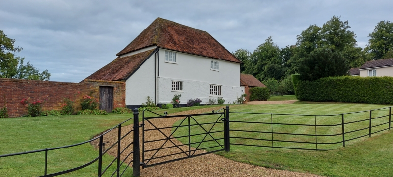
Entry Name: Church Farmhouse
Listing Date: 26 September 1980
Grade: II
Source: Historic England
Source ID: 1114694
English Heritage Legacy ID: 35987
ID on this website: 101114694
Location: Church End, Central Bedfordshire, LU7
County: Central Bedfordshire
Civil Parish: Hockliffe
Traditional County: Bedfordshire
Lieutenancy Area (Ceremonial County): Bedfordshire
Church of England Parish: Hockliffe
Church of England Diocese: St.Albans
Tagged with: Farmhouse
1.
5125 HOCKLIFFE CHURCH END: CHURCH LANE
Church Farmhouse
SP 9626 12/158
II
2.
Late C17. Colourwashed plaster. Two storeys. Hipped old clay tile roof. Two
3-light casement windows with glazing bars.
Listing NGR: SP9665326910
External links are from the relevant listing authority and, where applicable, Wikidata. Wikidata IDs may be related buildings as well as this specific building. If you want to add or update a link, you will need to do so by editing the Wikidata entry.


Other nearby listed buildings
