Latitude: 51.9287 / 51°55'43"N
Longitude: -0.5041 / 0°30'14"W
OS Eastings: 502957
OS Northings: 226628
OS Grid: TL029266
Mapcode National: GBR G4M.5C6
Mapcode Global: VHFR6.6SWC
Plus Code: 9C3XWFHW+F9
Entry Name: Manor Farmhouse
Listing Date: 26 September 1980
Grade: II
Source: Historic England
Source ID: 1114750
English Heritage Legacy ID: 36117
ID on this website: 101114750
Location: Chalton, Central Bedfordshire, LU4
County: Central Bedfordshire
Civil Parish: Chalton
Built-Up Area: Chalton
Traditional County: Bedfordshire
Lieutenancy Area (Ceremonial County): Bedfordshire
Church of England Parish: Toddington
Church of England Diocese: St.Albans
Tagged with: Farmhouse
1. TL 02 NW
5125 CHALTON LUTON ROAD
(west side)
Chalton
Manor Farmhouse
22/378
26.9.1980
II
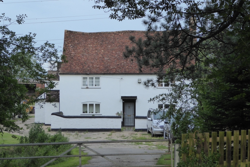
2.
C17, refronted in C18. Now colourwashed plaster. Two storeys. Old clay tile
roof. Two casements. Cut bracketed doorhood. Large side elevation projecting
chimney stack. Timber-framed rear wing with colourwashed brick nogging.
Two storeys. Two casements with glazing bars.
Listing NGR: TL0295726628
External links are from the relevant listing authority and, where applicable, Wikidata. Wikidata IDs may be related buildings as well as this specific building. If you want to add or update a link, you will need to do so by editing the Wikidata entry.


Other nearby listed buildings