Approximate Location Map
Large Map »
Latitude: 51.9285 / 51°55'42"N
Longitude: -0.5011 / 0°30'3"W
OS Eastings: 503163
OS Northings: 226613
OS Grid: TL031266
Mapcode National: GBR G4N.04P
Mapcode Global: VHFR6.8SGH
Plus Code: 9C3XWFHX+9H
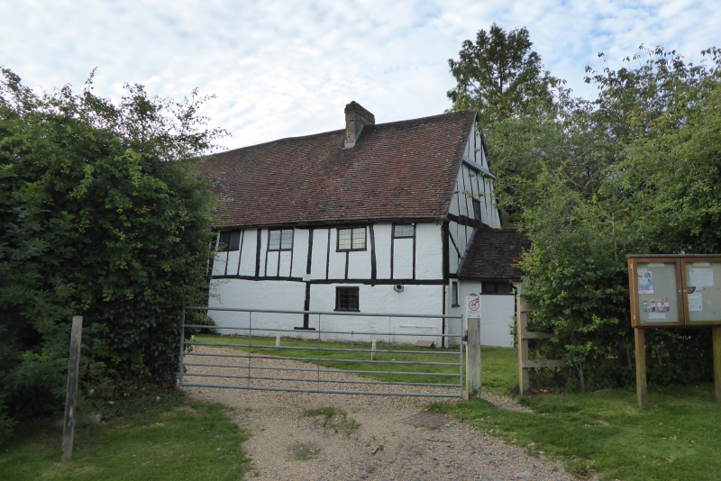
Entry Name: Barn End
Listing Date: 26 September 1980
Grade: II
Source: Historic England
Source ID: 1310951
English Heritage Legacy ID: 36114
ID on this website: 101310951
Location: Chalton, Central Bedfordshire, LU4
County: Central Bedfordshire
Civil Parish: Chalton
Built-Up Area: Chalton
Traditional County: Bedfordshire
Lieutenancy Area (Ceremonial County): Bedfordshire
Church of England Parish: Toddington
Church of England Diocese: St.Albans
Tagged with: Barn
TL 02 NW 22/376
CHALTON LUTON ROAD
(east side)
Chalton
22/376
26.9.1980 Barn End
II
C17. Timber-framed with whitewashed brick nogging. Two storeys. Old clay
tile roof. Modern casements.
Listing NGR: TL0316326613
External links are from the relevant listing authority and, where applicable, Wikidata. Wikidata IDs may be related buildings as well as this specific building. If you want to add or update a link, you will need to do so by editing the Wikidata entry.


Other nearby listed buildings
