Approximate Location Map
Large Map »
Latitude: 50.592 / 50°35'31"N
Longitude: -4.8322 / 4°49'56"W
OS Eastings: 199631
OS Northings: 80752
OS Grid: SW996807
Mapcode National: GBR ZV.GS00
Mapcode Global: FRA 07RH.R8F
Plus Code: 9C2QH5R9+R4
Entry Name: Fish Cellars
Listing Date: 6 June 1969
Grade: II
Source: Historic England
Source ID: 1115065
English Heritage Legacy ID: 351386
ID on this website: 101115065
Location: Port Isaac, Cornwall, PL29
County: Cornwall
Civil Parish: St. Endellion
Built-Up Area: Port Gaverne
Traditional County: Cornwall
Lieutenancy Area (Ceremonial County): Cornwall
Church of England Parish: Port Isaac
Church of England Diocese: Truro
Tagged with: Building
SW 98 SE
9/54
6.6.69
ST ENDELLION
FORE STREET, (north side),
Port Isaac
No 1 (Fish Cellars)
GV
II
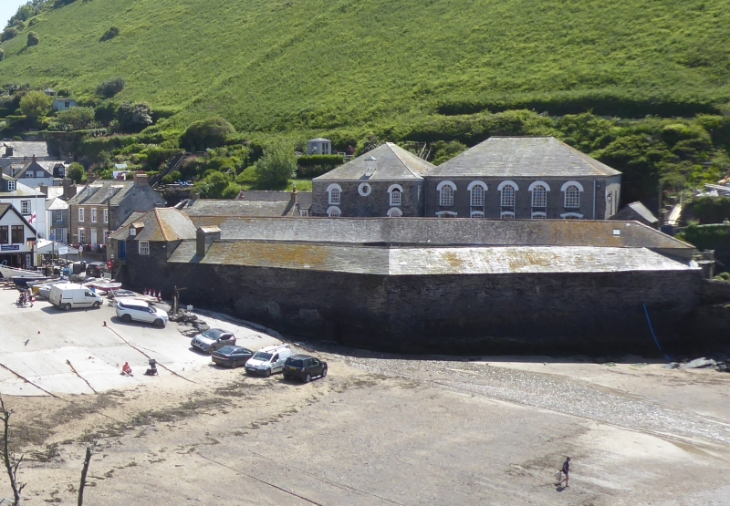
Fish cellars. Circa early C19. Stone rubble. Slate roof with hipped and gabled
ends.
Irregular courtyard plan with 2-storey range on front with wide opening in centre for
access to courtyard within. Canted rear projecting wing on left originally comprised
stables, salt pits, range open fronted to yard with arcade of timber and granite
posts and net lofts above. Canted rear projecting wing on right comprised later
kipper house, C20 lobster tanks and open-fronted sheds.
Front range of 2 storeys with asymmetrical 3-window front. Wide opening in centre of
ground floor with 3 hornless 12-pane sashes above and stone rubble external stair on
right-hand side leading up to offices on first floor. Rear projecting wing on left
partly rebuilt with part used as public convenience. Entrances to first floor net
lofts on Roscarrock Hill elevation.
The cellars were originally used for the pilchard industry. The catch was initially
layered with salt on the floor of the courtyard until the bulk had broken. It was
then loaded into leaky hogsheads which were arranged around the sides of the cellars
on timber boards positioned over shallow gullies. The fish were then crushed by
large stones suspended from long pressing beams which were slotted into brick niches
in the walls and the oil was pressed out of the hogsheads and was collected as it ran
along the gullies. The open sheds, gully and brick niches for the pressing holes
survive in the west range of these cellars. By the mid C19, when the pilchard catch
was declining, the cellars were partly adapted for herrings which were kippered in
the smoking house on the east. Part of this smoking house has now been converted
into a shop.
The cellars continue to be used by the fishing industry in Port Isaac which now
concentrates on lobsters and crabs.
Important elevations to the harbour, Fore Street and Roscarrock Hill.
Listing NGR: SW9963180752
External links are from the relevant listing authority and, where applicable, Wikidata. Wikidata IDs may be related buildings as well as this specific building. If you want to add or update a link, you will need to do so by editing the Wikidata entry.


Other nearby listed buildings
