Approximate Location Map
Large Map »
Latitude: 51.055 / 51°3'18"N
Longitude: 0.6299 / 0°37'47"E
OS Eastings: 584407
OS Northings: 131700
OS Grid: TQ844317
Mapcode National: GBR QW6.XR8
Mapcode Global: FRA D66B.H6L
Plus Code: 9F323J4H+2X
Entry Name: Chamberlaynes Tweedies
Listing Date: 16 August 1962
Grade: II
Source: Historic England
Source ID: 1115590
English Heritage Legacy ID: 180350
ID on this website: 101115590
Location: Rolvenden, Ashford, Kent, TN17
County: Kent
District: Ashford
Civil Parish: Rolvenden
Built-Up Area: Rolvenden
Traditional County: Kent
Lieutenancy Area (Ceremonial County): Kent
Tagged with: Building
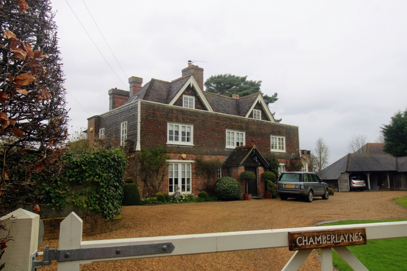
ROLVENDEN HIGH STREET
1.
5272 Chamberlaynes and Tweedies
TQ 8431 18/306 16.8.62.
II
2.
One house, now sub-divided. C18 or earlier building with C19 alterations.
Two storeys and attics. Ground floor red brick, above tile hung with some
curved tiles. Hipped tiled roof with 2 C19 gables having pendants and moulded
bargeboards. Parapet. Three casement windows. Modern porch. C19 additions
behind.
Listing NGR: TQ8440231702
External links are from the relevant listing authority and, where applicable, Wikidata. Wikidata IDs may be related buildings as well as this specific building. If you want to add or update a link, you will need to do so by editing the Wikidata entry.


Other nearby listed buildings
