Latitude: 51.5493 / 51°32'57"N
Longitude: -2.4602 / 2°27'36"W
OS Eastings: 368187
OS Northings: 183479
OS Grid: ST681834
Mapcode National: GBR JX.FMVJ
Mapcode Global: VH88B.9BR4
Plus Code: 9C3VGGXQ+PW
Entry Name: Hillside
Listing Date: 27 November 1984
Grade: II
Source: Historic England
Source ID: 1116050
English Heritage Legacy ID: 350700
ID on this website: 101116050
Location: Iron Acton, South Gloucestershire, BS37
County: South Gloucestershire
Civil Parish: Iron Acton
Built-Up Area: Iron Acton
Traditional County: Gloucestershire
Lieutenancy Area (Ceremonial County): Gloucestershire
Church of England Parish: Iron Acton
Church of England Diocese: Bristol
Tagged with: Building
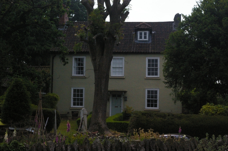
ST 68 SE IRON ACT ON HOLLY HILL ROAD
2/16 Hillside
G.V. II
House. Late C18/early C19. Rendered, pantile roofs. 2 storey, 3 windows,
all sashes, central 6-panel door (top 2 glazed) under flat hood on shaped
brackets. Later 1 ½ storey gabled extension at left (north).
Listing NGR: ST6818983481
External links are from the relevant listing authority and, where applicable, Wikidata. Wikidata IDs may be related buildings as well as this specific building. If you want to add or update a link, you will need to do so by editing the Wikidata entry.


Other nearby listed buildings