Approximate Location Map
Large Map »
Latitude: 52.0494 / 52°2'57"N
Longitude: -2.102 / 2°6'7"W
OS Eastings: 393100
OS Northings: 239010
OS Grid: SO931390
Mapcode National: GBR 2KC.HCG
Mapcode Global: VH93G.JR38
Plus Code: 9C4V2VXX+Q5
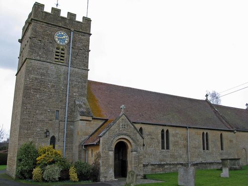
Entry Name: Church of St Giles
Listing Date: 3 August 1972
Grade: II
Source: Historic England
Source ID: 1117048
English Heritage Legacy ID: 442315
ID on this website: 101117048
Location: Bredon's Norton Church, Bredon's Norton, Wychavon, Worcestershire, GL20
County: Worcestershire
District: Wychavon
Civil Parish: Bredon's Norton
Traditional County: Worcestershire
Lieutenancy Area (Ceremonial County): Worcestershire
Church of England Parish: Bredon
Church of England Diocese: Worcester
Tagged with: Church building
BREDON'S NORTON BREDON'S NORTON
1.
2301
Church of St Giles
SO 93 NW 17/159 11.2.65.
C
2.
Entirely rebuilt in 1883 except the Norman tower, a reset Cl2 south doorway
and C13 chancel arch, with good foliage caps.
Listing NGR: SO9310039010
External links are from the relevant listing authority and, where applicable, Wikidata. Wikidata IDs may be related buildings as well as this specific building. If you want to add or update a link, you will need to do so by editing the Wikidata entry.


Other nearby listed buildings
