Approximate Location Map
Large Map »
Latitude: 51.5111 / 51°30'40"N
Longitude: -1.2055 / 1°12'19"W
OS Eastings: 455234
OS Northings: 179431
OS Grid: SU552794
Mapcode National: GBR 923.8AH
Mapcode Global: VHCZ1.282X
Plus Code: 9C3WGQ6V+CR
Entry Name: Dumworth Farm House
Listing Date: 3 June 1986
Grade: II
Source: Historic England
Source ID: 1117180
English Heritage Legacy ID: 39884
ID on this website: 101117180
Location: Parsonage Green, West Berkshire, RG8
County: West Berkshire
Civil Parish: Aldworth
Traditional County: Berkshire
Lieutenancy Area (Ceremonial County): Berkshire
Church of England Parish: Aldworth
Church of England Diocese: Oxford
Tagged with: Farmhouse
ALDWORTH TOWNSEND ROAD
SU 57 NE (South side)
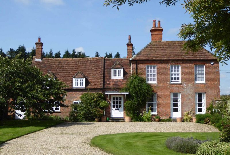
Dumworth Farm House
10/5
II
G.V.
Farm house. C16 with C17, C18, Cl9 and C20 alterations and additions.
Brick, render to south of central block; tiled roofs. Rough L plan of
central C16 block running east to west with C19 flat roofed extension
across north side, C16 crosswing re-worked Cl9 to west with C20
extension to south, C19 extension across end of central block to east,
linked by C20 block to former C18 brew house to south. 2 storeys in
main blocks, one and a half storeys in south blocks; 3 hipped C20
dormers on east 2 hipped C20 dormers to west of south block ; end
chimney to south of south block, ridge chimney to east of centre
block, chimney to north of east slope of west block. East Elevation:-
to left low block with two 3-light casements with cambered heads and
two C20 dormers; to centre C20 link block; to right taller C19 block
with 3 glazing bar sashes, those on the ground floor with marginal
glazing; half glazed C20 door under flat hood in link block. South
Elevation:- to left C20 extension with 2-light casement above french
casement; to centre rendered C16 block with irregular casements, two
2-light C19 casements on first floor and 2-light and 3-light C20
casements on ground floor, C20 extension at junction with right hand
block; to right lower block with 1 storey tiled roofed extension end
and two casements on first floor.
Listing NGR: SU5523479431
External links are from the relevant listing authority and, where applicable, Wikidata. Wikidata IDs may be related buildings as well as this specific building. If you want to add or update a link, you will need to do so by editing the Wikidata entry.


Other nearby listed buildings
