Approximate Location Map
Large Map »
Latitude: 51.5114 / 51°30'40"N
Longitude: -1.3824 / 1°22'56"W
OS Eastings: 442958
OS Northings: 179339
OS Grid: SU429793
Mapcode National: GBR 80J.5BY
Mapcode Global: VHCYY.081R
Plus Code: 9C3WGJ69+G3
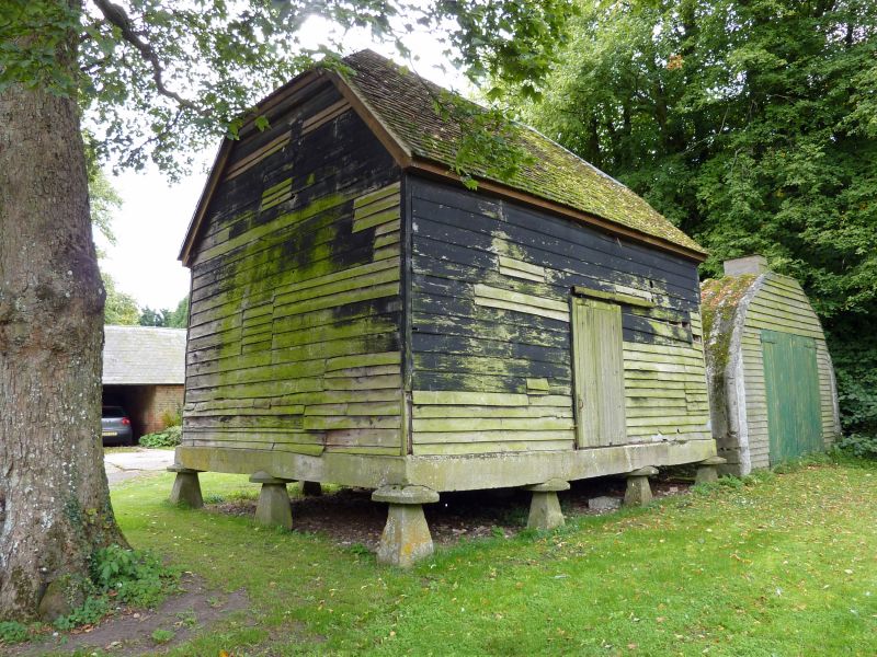
Entry Name: Granary 25 Metres North West of Manor Farm House
Listing Date: 27 June 1985
Grade: II
Source: Historic England
Source ID: 1117192
English Heritage Legacy ID: 39813
ID on this website: 101117192
Location: Brightwalton, West Berkshire, RG20
County: West Berkshire
Civil Parish: Brightwalton
Traditional County: Berkshire
Lieutenancy Area (Ceremonial County): Berkshire
Church of England Parish: Brightwalton with Catmore
Church of England Diocese: Oxford
Tagged with: Granary
SU 47 NW BRIGHTWALTON BRIGHTWALTON VILLAGE
7/22 Granary 25 metres North-
West of Manor Farm House
II
Granary. C18. Weatherboarding on timber frame; half hipped tiled roof.
Rectangular plan on 3 x 4 staddle stones. One storey. Boarded door in
east end.
Listing NGR: SU4295879339
External links are from the relevant listing authority and, where applicable, Wikidata. Wikidata IDs may be related buildings as well as this specific building. If you want to add or update a link, you will need to do so by editing the Wikidata entry.


Other nearby listed buildings
