Approximate Location Map
Large Map »
Latitude: 51.4504 / 51°27'1"N
Longitude: -0.878 / 0°52'40"W
OS Eastings: 478060
OS Northings: 172973
OS Grid: SU780729
Mapcode National: GBR C5Z.0T9
Mapcode Global: VHDWV.QTP0
Plus Code: 9C3XF42C+4Q
Entry Name: Sandford Mill Bridge
Listing Date: 26 January 1967
Grade: II
Source: Historic England
Source ID: 1118110
English Heritage Legacy ID: 41510
ID on this website: 101118110
Location: Wokingham, Berkshire, RG5
County: Wokingham
Civil Parish: Woodley
Built-Up Area: Woodley
Traditional County: Berkshire
Lieutenancy Area (Ceremonial County): Berkshire
Church of England Parish: Woodley St John the Evangelist
Church of England Diocese: Oxford
Tagged with: Bridge
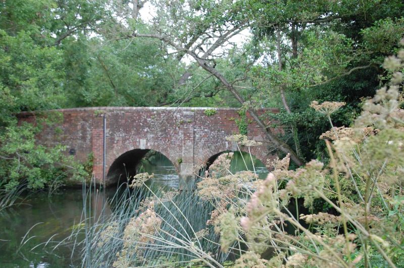
WOODLEY & SANDFORD SANDFORD LANE
SU 77 SE (east side)
5/50
26.1.67 Sandford Mill
Bridge
G.V. II
Road bridge over mill stream. Dated 1772. Brick with stone key blocks,
2 arches flanked by pilasters, brick parapet and approach walls. Stone
cut-waters on up stream side.
Listing NGR: SU7806072973
External links are from the relevant listing authority and, where applicable, Wikidata. Wikidata IDs may be related buildings as well as this specific building. If you want to add or update a link, you will need to do so by editing the Wikidata entry.


Other nearby listed buildings
