Approximate Location Map
Large Map »
Latitude: 51.7719 / 51°46'18"N
Longitude: -0.9287 / 0°55'43"W
OS Eastings: 474018
OS Northings: 208682
OS Grid: SP740086
Mapcode National: GBR C1V.S1S
Mapcode Global: VHDV8.VQFH
Plus Code: 9C3XQ3CC+QG
Entry Name: Apple Croft
Listing Date: 12 March 1980
Grade: II
Source: Historic England
Source ID: 1118267
English Heritage Legacy ID: 43181
ID on this website: 101118267
Location: Fort End, Buckinghamshire, HP17
County: Buckinghamshire
Civil Parish: Haddenham
Built-Up Area: Haddenham
Traditional County: Buckinghamshire
Lieutenancy Area (Ceremonial County): Buckinghamshire
Church of England Parish: Haddenham
Church of England Diocese: Oxford
Tagged with: Building
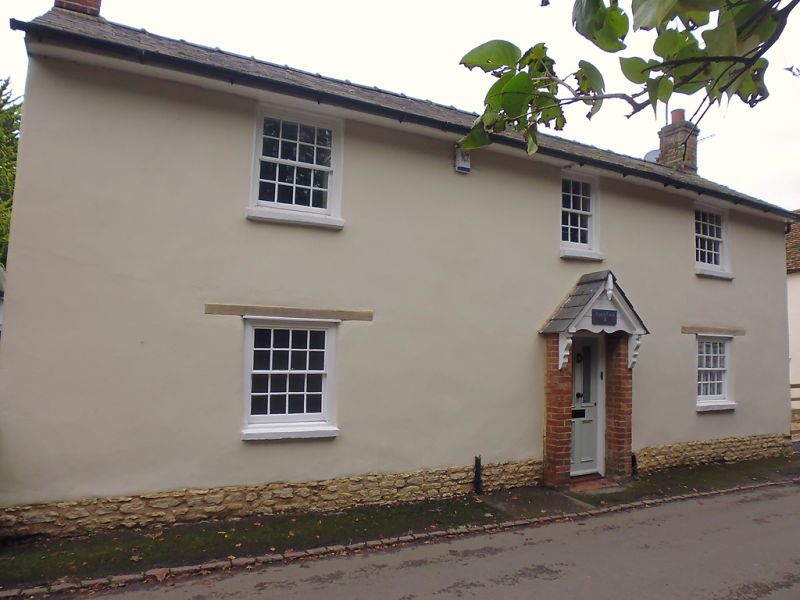
SP 7408 HADDENHAM HIGH STREET
(east side)
11/240 No.9 (Apple Croft)
12.3.80
GV II
Cottage. Circa 1835. Witchert on a rubblestone plinth, rendered and
colourwashed. Slate roof with gable stacks, 2 storeys and 3 bays. 4 pane
sashes, 3-pane over central door in shallow gabled porch with brick
piers and slate roof on shaped brackets. Rear addition under catslide
roof.
Listing NGR: SP7401708684
External links are from the relevant listing authority and, where applicable, Wikidata. Wikidata IDs may be related buildings as well as this specific building. If you want to add or update a link, you will need to do so by editing the Wikidata entry.


Other nearby listed buildings
