Approximate Location Map
Large Map »
Latitude: 51.7718 / 51°46'18"N
Longitude: -0.9287 / 0°55'43"W
OS Eastings: 474019
OS Northings: 208668
OS Grid: SP740086
Mapcode National: GBR C1V.S1V
Mapcode Global: VHDV8.VQFL
Plus Code: 9C3XQ3CC+PG
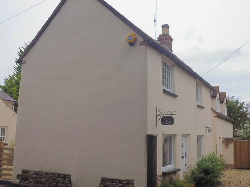
Entry Name: Myrtle Cottage
Listing Date: 11 October 1985
Grade: II
Source: Historic England
Source ID: 1118268
English Heritage Legacy ID: 43182
ID on this website: 101118268
Location: Haddenham, Buckinghamshire, HP17
County: Buckinghamshire
Civil Parish: Haddenham
Built-Up Area: Haddenham
Traditional County: Buckinghamshire
Lieutenancy Area (Ceremonial County): Buckinghamshire
Church of England Parish: Haddenham
Church of England Diocese: Oxford
Tagged with: Cottage
SP 7408 HADDENHAM HIGH STREET
(east side)
11/241 No.11 (Myrtle Cottage)
-
GV II
Cottage. Circa 1790. Render with incised masonry lines on witchert,
rubble plinth. Old tile roof with gable stacks. Centre door. 2-light
horizontal sliding sashes. Gable end fronts road. North elevation has
2-light casements, one to ground floor, two to first. Single storey
outbuilding to east.
Listing NGR: SP7401808668
External links are from the relevant listing authority and, where applicable, Wikidata. Wikidata IDs may be related buildings as well as this specific building. If you want to add or update a link, you will need to do so by editing the Wikidata entry.


Other nearby listed buildings
