Latitude: 50.7341 / 50°44'2"N
Longitude: -2.7542 / 2°45'14"W
OS Eastings: 346873
OS Northings: 92987
OS Grid: SY468929
Mapcode National: GBR PP.L64M
Mapcode Global: FRA 5734.JV8
Plus Code: 9C2VP6MW+J8
Entry Name: 22, Barrack Street
Listing Date: 19 September 1975
Grade: II
Source: Historic England
Source ID: 1119019
English Heritage Legacy ID: 104459
ID on this website: 101119019
Location: Bridport, Dorset, DT6
County: Dorset
Civil Parish: Bridport
Built-Up Area: Bridport
Traditional County: Dorset
Lieutenancy Area (Ceremonial County): Dorset
Church of England Parish: Bridport St Mary
Church of England Diocese: Salisbury
Tagged with: Building
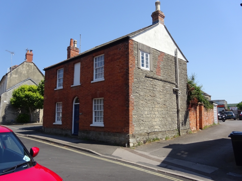
1.
5191 BARRACK STREET
(East Side)
No 22
SY 4692 1/207
II GV
2.
C18 or early Cl7. Red brick. Hammer dressed stone plinth. Pitched slate
roof. Cl9 stacks. 2 storeys. 2 ranges of sashes with glazing bars. 1 trompe
l'oeuil window on 1st floor. Door with 2 moulded panels and fanlight with
depressed arched head.
Nos 2 to 26 (even) form a group.
Listing NGR: SY4688092985
External links are from the relevant listing authority and, where applicable, Wikidata. Wikidata IDs may be related buildings as well as this specific building. If you want to add or update a link, you will need to do so by editing the Wikidata entry.


Other nearby listed buildings