Latitude: 51.0737 / 51°4'25"N
Longitude: 1.0903 / 1°5'25"E
OS Eastings: 616582
OS Northings: 135031
OS Grid: TR165350
Mapcode National: GBR V0M.LGF
Mapcode Global: FRA F658.W0T
Plus Code: 9F3333FR+F4
Entry Name: Hythe Town Reservoir
Listing Date: 13 May 1998
Last Amended: 24 June 1998
Grade: II
Source: Historic England
Source ID: 1119742
English Heritage Legacy ID: 469265
ID on this website: 101119742
Location: Hythe, Folkestone and Hythe, Kent, CT21
County: Kent
District: Folkestone and Hythe
Civil Parish: Hythe
Built-Up Area: Hythe
Traditional County: Kent
Lieutenancy Area (Ceremonial County): Kent
Tagged with: Building
TR 13 NE HYTHE
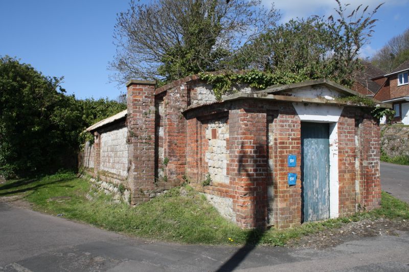
6/10000 Hythe Town Reservoir
II
Covered reservoir. Dated 1868. Classical style covering building of ashlar ragstone with red brick dressings and roof now covered in corrugated tin. T-shaped and aligned roughly east-west.
The long walls are of dressed ragstone with plinth, brick margins and pilasters but the inner skin is of brick and rubble stone mixed. Barrel-vaulted roof but wall-head mutilated when the roof was replaced so may have been pitched originally. At the east end is a small porch, primarily of brick with dressed ragstone ashlar used for side walls. This has stone pediment, pilasters and recessed panels of alternate brick and stone and central entrance with flat arch, voussoirs and plank door. The whole internal area is occupied by the reservoir tank which is about three metres deep. The reservoir walls are built in brick and rendered. The interior of the main range is sub-divided by two cross walls with large segmantal arch spans in the centres making the tank one large space. Similar cross walls separate at the short wings at the western end from the main range. Water appears to have entered the tank directly from springs through two or three pipes at its eastern end and left from a single pipe in the bottom of the south western wing. These fittings are reported to be still present but appear to be of quite modern date. This reservoir was on the site of an old Tan Pit and the water came from a spring on land owned by Henry Bean Mackeson, Maltster, who claimed a right to the water. Agreement was reached in 1868 by which the Hythe Corporation became entitled to one half of the yield and the other half became the property of the Landowner who used it in his brew. This arrangement continued until the brewery closed.
Listing NGR: TR1658235031
External links are from the relevant listing authority and, where applicable, Wikidata. Wikidata IDs may be related buildings as well as this specific building. If you want to add or update a link, you will need to do so by editing the Wikidata entry.


Other nearby listed buildings