Approximate Location Map
Large Map »
Latitude: 54.5793 / 54°34'45"N
Longitude: -1.5599 / 1°33'35"W
OS Eastings: 428546
OS Northings: 520544
OS Grid: NZ285205
Mapcode National: GBR KHKH.27
Mapcode Global: WHC5Q.05H8
Plus Code: 9C6WHCHR+P3
Entry Name: Coatham Hall Farmhouse
Listing Date: 6 June 1952
Last Amended: 28 January 1987
Grade: II
Source: Historic England
Source ID: 1121235
English Heritage Legacy ID: 110756
ID on this website: 101121235
Location: Coatham Mundeville, Darlington, County Durham, DL3
County: Darlington
Civil Parish: Coatham Mundeville
Traditional County: Durham
Lieutenancy Area (Ceremonial County): County Durham
Church of England Parish: Great Aycliffe
Church of England Diocese: Durham
Tagged with: Farmhouse
In the entry for:
NZ 2820 COATHAM MUNDEVILLE COATHAM LANE
12/167 (north side)
6/6/52 Coatham Farmhouse
GV II
The address shall be amended to read:
COATHAM LANE
(north side)
Coatham Hall Farmhouse
In the descriptive notes the words "...incorrectly shown on O.S. Map as Coatham
Hall Farmhouse" shall be deleted.
------------------------------------
NZ 2820 COATHAM MUNDEVILLE COATHAM LANE
(North side)
12/167 Coatham Farmhouse
6/6/52
GV II
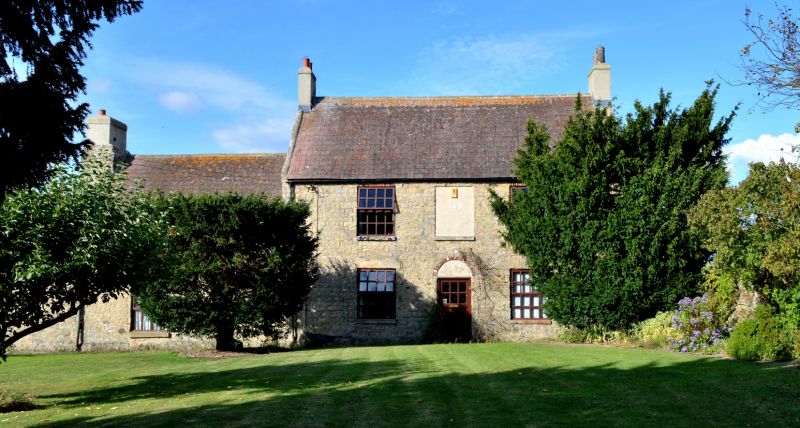
Farmhouse, incorrectly shown on O.S. Map as Coatham Hall Farmhouse. Probably
early C17 with early C18 and C19 additions. Coursed rubble; early C18 section
squared limestone. Artificial slate and pantiled roofs. Brick and stone
chimney stacks. Linear plan: original farmhouse with early C18 farmhouse to
right and C19 single-storey range to left.
2-storey original house has rough boulder plinth and flush quoins at junction
to right. One window wide: replaced casements in enlarged openings. Roof
has raised left verge. Massive end chimney with rough offsets rises through
roof of range to left.
Taller 2-storey, 3-bay farmhouse at right has low plinth. Central replaced
door and blocked fanlight under brick arch. Replaced casements and boarded
window above door. Steeply-pitched roof with slightly-swept eaves, and raised
verges. Rendered brick end stacks.
Single-storey, 2-window L-plan range on left of centre section has 2 late C20
windows and steeply-pitched pantiled roof.
2-storey gabled stair wing (possibly C17) on rear of early C18 farmhouse, has
stepped external chimney on rear gable and steeply-pitched roof. Stair window
with radial head on left return. Single-storey added outshut with pent roof
on right return.
Listing NGR: NZ2854620544
External links are from the relevant listing authority and, where applicable, Wikidata. Wikidata IDs may be related buildings as well as this specific building. If you want to add or update a link, you will need to do so by editing the Wikidata entry.


Other nearby listed buildings
