Approximate Location Map
Large Map »
Latitude: 52.0767 / 52°4'36"N
Longitude: -0.7821 / 0°46'55"W
OS Eastings: 483564
OS Northings: 242736
OS Grid: SP835427
Mapcode National: GBR CZP.M4C
Mapcode Global: VHDT0.D2DB
Plus Code: 9C4X36G9+M5
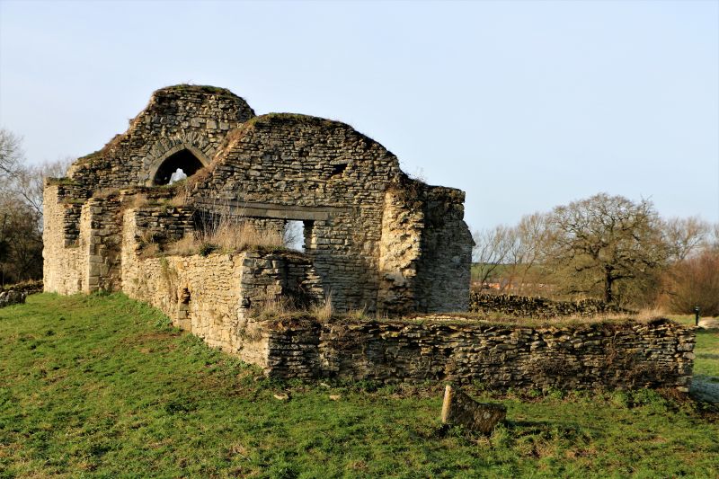
Entry Name: Ruins of Church of St Peter
Listing Date: 17 November 1966
Grade: II
Source: Historic England
Source ID: 1125226
English Heritage Legacy ID: 45901
ID on this website: 101125226
Location: Stanton Low Park, Milton Keynes, Buckinghamshire, MK14
County: Milton Keynes
Civil Parish: Haversham-cum-Little Linford
Traditional County: Buckinghamshire
Lieutenancy Area (Ceremonial County): Buckinghamshire
Church of England Parish: Stantonbury and Willen
Church of England Diocese: Oxford
Tagged with: Building
SP 84 SW STANTONBURY WOLVERTON ROAD
north side (off)
1/115 Ruins of Church of St.
Peter
17.11.66
II
Ruins of former parish church. Norman and Cl5, restored early C20
but now a fragmentary ruin. Rubble limestone, walls only. The E.
wall of the chancel almost complete, with the arch of a C14 window.
Listing NGR: SP8356442736
External links are from the relevant listing authority and, where applicable, Wikidata. Wikidata IDs may be related buildings as well as this specific building. If you want to add or update a link, you will need to do so by editing the Wikidata entry.


Other nearby listed buildings
