Approximate Location Map
Large Map »
Latitude: 51.6143 / 51°36'51"N
Longitude: -0.8948 / 0°53'41"W
OS Eastings: 476622
OS Northings: 191184
OS Grid: SU766911
Mapcode National: GBR C3T.NMK
Mapcode Global: VHDW2.FPTC
Plus Code: 9C3XJ474+P3
Entry Name: Barn Circa 25 Metres to North West of the Old Vicarage
Listing Date: 22 January 1986
Grade: II
Source: Historic England
Source ID: 1125642
English Heritage Legacy ID: 46832
ID on this website: 101125642
Location: Turville, Buckinghamshire, RG9
County: Buckinghamshire
Civil Parish: Turville
Traditional County: Buckinghamshire
Lieutenancy Area (Ceremonial County): Buckinghamshire
Church of England Parish: Turville
Church of England Diocese: Oxford
Tagged with: Barn
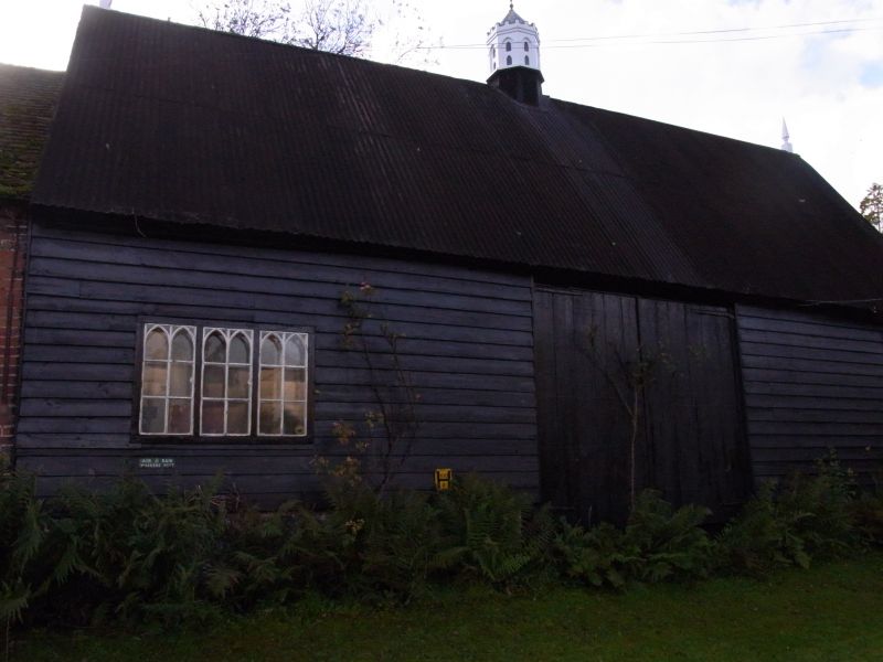
SU 79 SE TURVILLE TURVILLE VILLAGE
(south side)
3/180 Barn c.25m. to N.W. of The
Old Vicarage
GV II
Barn. Probably mid C18, altered C20. Timber frame and weatherboard,
flint plinth, corrugated iron roof (formerly thatched). 3 bays.
Side to road has central cart doors, and 3-light metal casement with
Gothick glazing bars to left. Below window is a small metal sign
inscribed "Air Raid Warden's Post" . Rear has central gabled projection
and stable-type door in left bay. Roof has C20 wooden finials at each
end and C20 central octagonal wooden turret with small battlements and
arched openings. Interior: roof trusses have curved queen posts and
curved braces to tie beams. Included for group value.
Listing NGR: SU7662291184
External links are from the relevant listing authority and, where applicable, Wikidata. Wikidata IDs may be related buildings as well as this specific building. If you want to add or update a link, you will need to do so by editing the Wikidata entry.


Other nearby listed buildings
