Approximate Location Map
Large Map »
Latitude: 51.5721 / 51°34'19"N
Longitude: -0.8705 / 0°52'13"W
OS Eastings: 478376
OS Northings: 186524
OS Grid: SU783865
Mapcode National: GBR C4F.8S3
Mapcode Global: VHDW8.VRP5
Plus Code: 9C3XH4CH+VR
Entry Name: Post Office
Listing Date: 22 January 1986
Grade: II
Source: Historic England
Source ID: 1125684
English Heritage Legacy ID: 46730
ID on this website: 101125684
Location: Hambleden, Buckinghamshire, RG9
County: Buckinghamshire
Civil Parish: Hambleden
Traditional County: Buckinghamshire
Lieutenancy Area (Ceremonial County): Buckinghamshire
Church of England Parish: Hambleden with Frieth
Church of England Diocese: Oxford
Tagged with: Post office
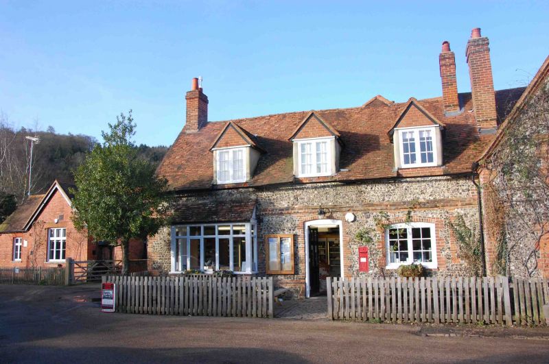
SU 78 NE HAMBLEDEN HAMBLEDEN VILLAGE
6/80 No. 58 (Post Office)
GV
II
House and shop. Part possibly C16, rebuilt early-mid C18, altered.
Flint with narrow brick dressings, first floor band course, off-set plinth,
plain tile roof, rebuilt flanking brick chimneys. L-plan. One storey
and attic, 2 bays. C20 paired barred wooden casements to ground floor right
and in 3 gabled eaves-line dormers; C20 projecting shop-front to left;
central C19 half-glazed door with stop-chamfered frame. Ground floor left
openings have segmental heads. Post box in wall to right of door. Door
to telephone box in left gable. Small lean-to in angle with rear wing.
Interior: heavy curved principal trusses set into wall at tie beam level;
very heavy floor joists in rear wing.
Listing NGR: SU7837686524
External links are from the relevant listing authority and, where applicable, Wikidata. Wikidata IDs may be related buildings as well as this specific building. If you want to add or update a link, you will need to do so by editing the Wikidata entry.


Other nearby listed buildings
