Approximate Location Map
Large Map »
Latitude: 51.6215 / 51°37'17"N
Longitude: -0.8437 / 0°50'37"W
OS Eastings: 480142
OS Northings: 192041
OS Grid: SU801920
Mapcode National: GBR C3W.9HX
Mapcode Global: VHDW3.BH9T
Plus Code: 9C3XJ5C4+HG
Entry Name: Finings
Listing Date: 21 June 1955
Last Amended: 22 January 1986
Grade: II
Source: Historic England
Source ID: 1125710
English Heritage Legacy ID: 46691
ID on this website: 101125710
Location: Bolter End, Buckinghamshire, HP14
County: Buckinghamshire
Civil Parish: Lane End
Traditional County: Buckinghamshire
Lieutenancy Area (Ceremonial County): Buckinghamshire
Church of England Parish: Lane End
Church of England Diocese: Oxford
Tagged with: Building
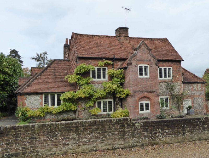
SU 89 SW FINGEST AND LANE END FININGS ROAD
Bolter End
4/39 Finings (formerly listed as
Finings Farmhouse)
21.6.55
GV II
House. Late C17-C18, altered and extended early C19. Flint with narrow
brick dressings to lower walls, upper storey raised in red and
vitreous brick, partly chequered, early C19, Tile-hung left gable,
rendered right gable. Old tile roof, central square brick chimney.
2 storeys, 2 bays. Off-set plinth, narrow band course just above
ground floor windows. C20 3-light leaded casements, those to ground
floor with segmental arches of header brick, those to first floor
with gauged heads. Central brick projection of c.1840, formerly a
porch, of 2 storeys with shaped gable and 2-light leaded casements.
Upper window has Tudor hoodmould, lower is in blocked doorway with
4-centred arch and Tudor dripmould. Single storey flint and brick
extension to left, altered C20; early C19 flint and brick wing set back
at angle to right, with hipped roof, l½ storeys, C20 leaded casements, and
C20 door to right.
Listing NGR: SU8014292041
External links are from the relevant listing authority and, where applicable, Wikidata. Wikidata IDs may be related buildings as well as this specific building. If you want to add or update a link, you will need to do so by editing the Wikidata entry.


Other nearby listed buildings
