Approximate Location Map
Large Map »
Latitude: 51.6592 / 51°39'33"N
Longitude: -0.9022 / 0°54'7"W
OS Eastings: 476034
OS Northings: 196172
OS Grid: SU760961
Mapcode National: GBR C37.SVN
Mapcode Global: VHDVW.9KXD
Plus Code: 9C3XM35X+M4
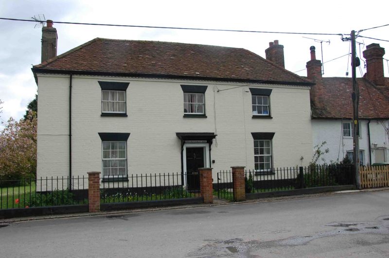
Entry Name: The Barley Mow
Listing Date: 4 July 1985
Grade: II
Source: Historic England
Source ID: 1125725
English Heritage Legacy ID: 46633
ID on this website: 101125725
Location: Stokenchurch, Buckinghamshire, HP14
County: Buckinghamshire
Civil Parish: Stokenchurch
Built-Up Area: Stokenchurch
Traditional County: Oxfordshire
Lieutenancy Area (Ceremonial County): Buckinghamshire
Church of England Parish: Stokenchurch
Church of England Diocese: Oxford
Tagged with: Building
STOKENCHURCH THE COMMON
SU 79 NE
2/154 The Barley Mow
-
GV II
House, formerly a public house. Circa 1800. Colourwashed brick, the
left end roughcast and colourwashed. Narrow dentil eaves, hipped old
tile roof, flanking brick chimneys, the left rendered. L-plan.
2 storeys, 3 bays. 3-pane sash windows with gauged brick heads. Central
6-panelled door in moulded architrave frame with cornice hood on
grooved scroll brackets. Interior has good 2-panel doors in architrave
frames, moulded wooden surrounds to fireplaces at right end, and central
stairs with column newels and stick balusters.
Listing NGR: SU7602796172
External links are from the relevant listing authority and, where applicable, Wikidata. Wikidata IDs may be related buildings as well as this specific building. If you want to add or update a link, you will need to do so by editing the Wikidata entry.


Other nearby listed buildings
