Latitude: 52.3986 / 52°23'54"N
Longitude: 0.2599 / 0°15'35"E
OS Eastings: 553849
OS Northings: 280241
OS Grid: TL538802
Mapcode National: GBR M6H.LJK
Mapcode Global: VHHJ6.GZ74
Plus Code: 9F4297X5+CW
Entry Name: Parish Church of St Mary
Listing Date: 23 September 1950
Grade: I
Source: Historic England
Source ID: 1126519
English Heritage Legacy ID: 48664
Also known as: St Mary's Church, Ely
ID on this website: 101126519
Location: St Mary's Church, Ely, East Cambridgeshire, CB7
County: Cambridgeshire
District: East Cambridgeshire
Civil Parish: Ely
Built-Up Area: Ely
Traditional County: Cambridgeshire
Lieutenancy Area (Ceremonial County): Cambridgeshire
Church of England Parish: Ely
Church of England Diocese: Ely
Tagged with: Church building
606/2/2 PARISH CHURCH OF ST MARY
23-SEP-50
GV I
Revision Number: 2
Parish Church of St Mary
1.
1082
TL 5379 2/2
23.9.50.
{GV}
2.
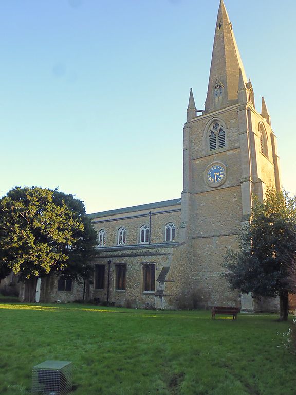
A stone rubble church with ashlars dressing. Mainly C13 with later work. The Church was begun in the warly part of the C13 by Bishop Eustace (1198-1215). It has a wide nave of 7 bays (Transitional) with slender plain piers and captials with scalloped ornamentation. THe clerestory is C15. The fine north doorway is early C13, with orders, columns with shaft riings, stiff-leaf capitals and a pointed arch with chevron ornamentation. Most likely it was the work of craftsment from the Cathedral workshop. The chancel has lancet windows on the south side (except the 1st window from the west end) and perpendicular windows on the north side. The west tower and stone spire is of the C14. The tower has angle buttresses with 3 offsets and corner pinnacles and the spire has tall arched dormer windows at the base and small dormer windows near the top.
The Parish Church of St Mary forms a group with Nos 13 to 19 (odd), Nos 20 to 30 (consec), Parson's Almshouses, No. 34, 36, 36A, 38, Nos 40 to 60 (even), St. Mary's Street and No. 20 Church Lane.
Listing NGR: TL5384980241
External links are from the relevant listing authority and, where applicable, Wikidata. Wikidata IDs may be related buildings as well as this specific building. If you want to add or update a link, you will need to do so by editing the Wikidata entry.


Other nearby listed buildings