Approximate Location Map
Large Map »
Latitude: 52.3985 / 52°23'54"N
Longitude: 0.2591 / 0°15'32"E
OS Eastings: 553797
OS Northings: 280237
OS Grid: TL537802
Mapcode National: GBR M6H.L9Z
Mapcode Global: VHHJ6.FZT5
Plus Code: 9F4297X5+CJ
Entry Name: Parsons' Almshouses
Listing Date: 19 June 1972
Grade: II
Source: Historic England
Source ID: 1252295
English Heritage Legacy ID: 435271
ID on this website: 101252295
Location: Ely, East Cambridgeshire, CB7
County: Cambridgeshire
District: East Cambridgeshire
Civil Parish: Ely
Built-Up Area: Ely
Traditional County: Cambridgeshire
Lieutenancy Area (Ceremonial County): Cambridgeshire
Church of England Parish: Ely
Church of England Diocese: Ely
Tagged with: Almshouse
This list entry was subject to a Minor Amendment on 20 April 2023 to amend the name and address, correct date of consruction and reformat the text to current standards
TL 5379
2/211
TL 5380
4/211
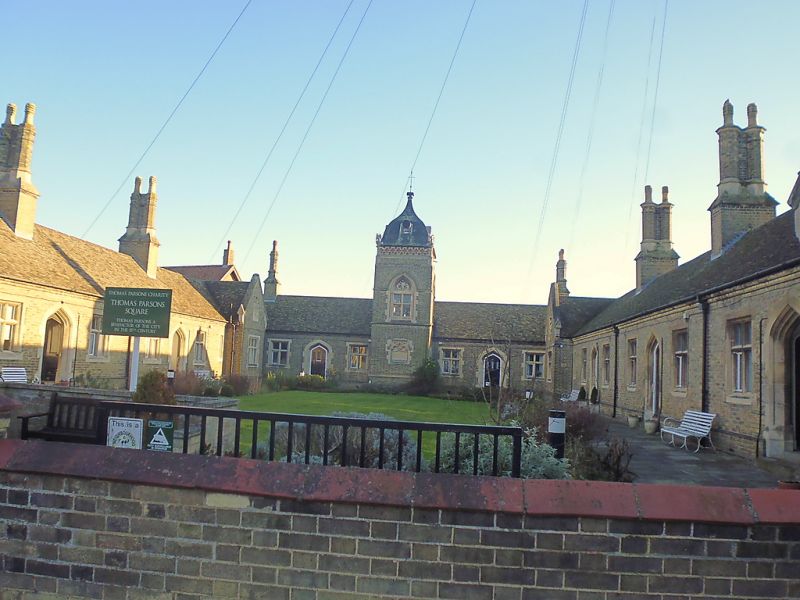
THOMAS PARSONS SQUARE
Parsons' Almshouses
(Formerly listed as Parson's Almshouses, ST MARY'S STREET (South Side)
GV
II
A range of buff coloured brick almshouses with stone dressings designed by G Basevi in the Tudor style and built in 1844. They have a long U-shaped plan with a central tower on the south range and long single scorched wings extending to the north with short gabled cross wings to terminate the north ends. The windows are mainly two-light, with some three-light, casements with stone mullions and transomes. The doorways have four-centred stone arches, lime central tower has an ogee slate roof with ornamental dormers, a central pointed arched window and a stone panel inscribed "These almshouses were erected 1844 through tile munificence of Thomas Parsons,an Ely benefactor of the 15th century". Roofs tiled, with paired circular chimney shafts on moulded bases.
Nos 13 to 29 (odd) and 29A, Parsons' Almshouses form a group with Nos 20, 22. 22A, Nos 24 to 30 (even), Nos 34, 36, 36A, 38, Nos 40 to 60 (even), No 20 Church Lane and Parish Church of St Mary. Also Nos 13 to 29 (odd) 29A Parsons' Almshouses & Nos 20, 22, 22A, Nos 24 to 30 (even), Nos 34, 36, 36A, 38 & Nos 40 to 60 (even) form a group with Nos 1 to 5 Downham Road.
Listing NGR: TL5379780237
External links are from the relevant listing authority and, where applicable, Wikidata. Wikidata IDs may be related buildings as well as this specific building. If you want to add or update a link, you will need to do so by editing the Wikidata entry.


Other nearby listed buildings
