Approximate Location Map
Large Map »
Latitude: 52.1913 / 52°11'28"N
Longitude: -0.0657 / 0°3'56"W
OS Eastings: 532315
OS Northings: 256550
OS Grid: TL323565
Mapcode National: GBR K5X.N5J
Mapcode Global: VHGMQ.T53Z
Plus Code: 9C4X5WRM+GP
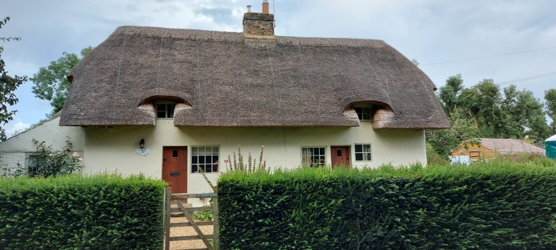
Entry Name: 20 and 22, Riddy Lane
Listing Date: 31 May 1985
Grade: II
Source: Historic England
Source ID: 1127185
English Heritage Legacy ID: 51074
ID on this website: 101127185
Location: Bourn, South Cambridgeshire, CB23
County: Cambridgeshire
District: South Cambridgeshire
Civil Parish: Bourn
Built-Up Area: Bourn
Traditional County: Cambridgeshire
Lieutenancy Area (Ceremonial County): Cambridgeshire
Church of England Parish: Bourn St Helena and St Mary
Church of England Diocese: Ely
Tagged with: Building
TL 3256-3356
15/45
BOURN
RIDDY LANE
(North-West Side)
Nos. 20 and 22
GV
II
Pair of cottages. C18 or later. Timber-framed and plastered, painted brick
foundations. Thatched half hipped roof. Central gault brick stack. One
storey and attics. Two boarded doors and fixed-light windows (No. 22 with
painted brick leanto). Two small dormer windows.
Listing NGR: TL3231556550
External links are from the relevant listing authority and, where applicable, Wikidata. Wikidata IDs may be related buildings as well as this specific building. If you want to add or update a link, you will need to do so by editing the Wikidata entry.


Other nearby listed buildings
