Approximate Location Map
Large Map »
Latitude: 51.44 / 51°26'23"N
Longitude: -2.8525 / 2°51'8"W
OS Eastings: 340844
OS Northings: 171563
OS Grid: ST408715
Mapcode National: GBR JC.NK67
Mapcode Global: VH7C7.H2WG
Plus Code: 9C3VC4QX+X2
Entry Name: 7, Hill Road
Listing Date: 22 January 1976
Grade: II
Source: Historic England
Source ID: 1129676
English Heritage Legacy ID: 33077
ID on this website: 101129676
Location: Clevedon, North Somerset, BS21
County: North Somerset
Civil Parish: Clevedon
Built-Up Area: Clevedon
Traditional County: Somerset
Lieutenancy Area (Ceremonial County): Somerset
Tagged with: Building
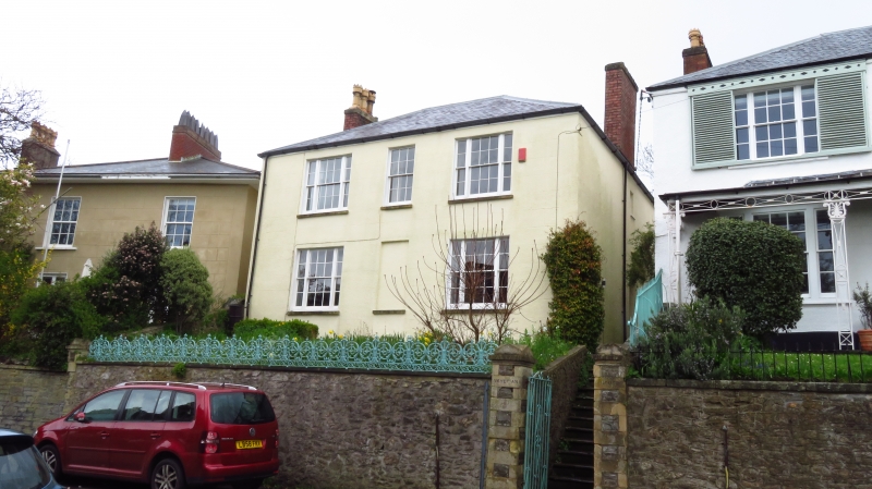
1. HILL ROAD
5l21
(North East Side)
No 7
ST 4071 1/69
II GV
2.
Adjoins No 9. 2 storey mid C19 house with rendered front. Incised masonry detail.
Hipped slate roof. 3 windows with triple lights to sides. Sashes with glazing
bars. Included for group value only.
Nos 5 to 17 (odd), 17a, 19 and 21 form a group.
Listing NGR: ST4084471563
External links are from the relevant listing authority and, where applicable, Wikidata. Wikidata IDs may be related buildings as well as this specific building. If you want to add or update a link, you will need to do so by editing the Wikidata entry.


Other nearby listed buildings
