Approximate Location Map
Large Map »
Latitude: 53.1426 / 53°8'33"N
Longitude: -2.3587 / 2°21'31"W
OS Eastings: 376104
OS Northings: 360664
OS Grid: SJ761606
Mapcode National: GBR 010.Y7M
Mapcode Global: WH9B0.R80N
Plus Code: 9C5V4JVR+2G
Entry Name: Sandbach Bridge
Listing Date: 27 April 1978
Grade: II
Source: Historic England
Source ID: 1130360
English Heritage Legacy ID: 56227
ID on this website: 101130360
Location: Sandbach, Cheshire East, Cheshire, CW11
County: Cheshire East
Civil Parish: Sandbach
Built-Up Area: Sandbach
Traditional County: Cheshire
Lieutenancy Area (Ceremonial County): Cheshire
Church of England Parish: Sandbach
Church of England Diocese: Chester
Tagged with: Bridge
HIGH STREET
1.
5144
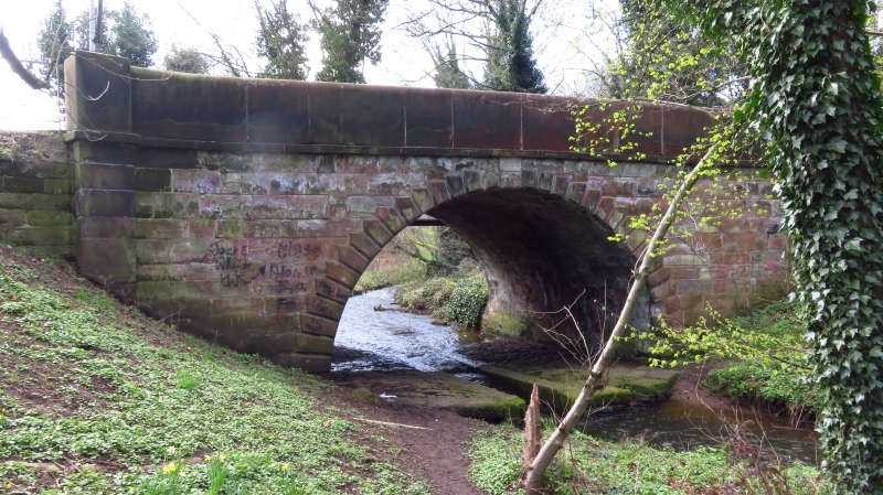
Sandbach Bridge
SJ 7660 2/74
II
2.
Early C19. Stone-built with single semi-circular arch, each side with keyblock
and rusticated voussoirs. Parapets of massive stone slabs with end piers and
stone radiused end sweeps.
Listing NGR: SJ7610460663
External links are from the relevant listing authority and, where applicable, Wikidata. Wikidata IDs may be related buildings as well as this specific building. If you want to add or update a link, you will need to do so by editing the Wikidata entry.


Other nearby listed buildings
