Latitude: 53.1275 / 53°7'39"N
Longitude: -2.6901 / 2°41'24"W
OS Eastings: 353921
OS Northings: 359149
OS Grid: SJ539591
Mapcode National: GBR 7L.6T8X
Mapcode Global: WH88Q.NN67
Plus Code: 9C5V48H5+2X
Entry Name: Walls of the Outer Bailey at Beeston Castle
Listing Date: 1 March 1967
Last Amended: 3 April 1986
Grade: I
Source: Historic England
Source ID: 1130513
English Heritage Legacy ID: 55799
ID on this website: 101130513
Location: Beeston, Cheshire West and Chester, Cheshire, CW6
County: Cheshire West and Chester
Civil Parish: Beeston
Traditional County: Cheshire
Lieutenancy Area (Ceremonial County): Cheshire
Church of England Parish: Bunbury St Boniface
Church of England Diocese: Chester
Tagged with: Wall
SJ 55 NW,
5/9
BEESTON C.P.,
(Off) CASTLE ROAD,
Walls of the Outer Bailey at Beeston Castle
(formerly listed as: Beeston Castle)
01.03.67.
G.V.
I
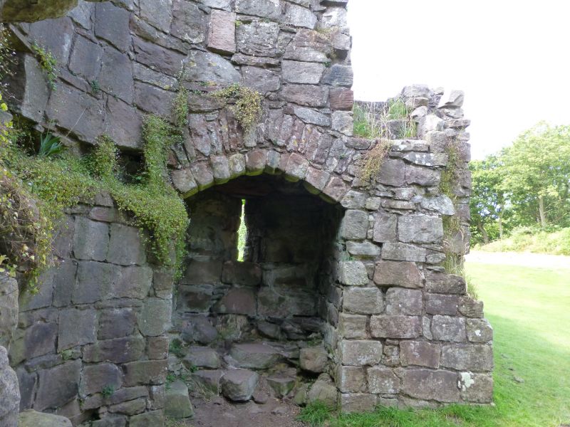
Section of walling, gatehouse and towers of outer bailey wall. c.1220
altered late C13/early C14. Built for Ranulf de Blundeville, 7th Earl
of Chester. Roughly coursed red sandstone. There is a break in the
walling at the point of the former gatehouse. The southern walling
has six D-shaped and one rectangular tower. At the northern end of
the wall are remnants of the southern tower of the gatehouse.
Immediately to the left of this and adjacent is a later C15 or C16
square garderobe tower. To the left of this are 5 further D-shaped
towers divided by curtain walling. Each tower has one or two lateral
arrow slits covering the curtain walls. The northern walling has
three D-shaped towers. At the southern end of the wall are remnants
of the northern tower of the gatehouse. The lower courses of the
walls and towers are all that remain, the upper courses having been
demolished c.1646 or thereafter. On the death of Ranulf de
Blundeville's nephew the castle passed to the Crown. In the late C13
and early C14 Edward I carried out modernising alterations. By the
late C16 Leland described the castle as "shattered and ruinous". In
1643 it was partially repaired and occupied by parliamentary troops
and taken by Royalist forces in the same year. It was partially
demolished in 1646 to prevent its repeated use as a stronghold.
Archaeological evidence of Bronze and Iron-age settlements on the site
has been found.
Listing NGR: SJ5393159215
External links are from the relevant listing authority and, where applicable, Wikidata. Wikidata IDs may be related buildings as well as this specific building. If you want to add or update a link, you will need to do so by editing the Wikidata entry.


Other nearby listed buildings