Latitude: 54.2912 / 54°17'28"N
Longitude: -1.9094 / 1°54'33"W
OS Eastings: 405995
OS Northings: 488397
OS Grid: SE059883
Mapcode National: GBR HL3T.FH
Mapcode Global: WHB5R.MDZN
Plus Code: 9C6W73RR+F6
Entry Name: The Hollies East and The Hollies West
Listing Date: 13 February 1967
Last Amended: 24 January 1986
Grade: II
Source: Historic England
Source ID: 1130849
English Heritage Legacy ID: 321866
ID on this website: 101130849
Location: West Witton, North Yorkshire, DL8
County: North Yorkshire
District: Richmondshire
Civil Parish: West Witton
Traditional County: Yorkshire
Lieutenancy Area (Ceremonial County): North Yorkshire
Tagged with: Architectural structure
This list entry was subject to a Minor Amendment on 23 September 2024 to update the name, address and reformat the text to current standards
SE 08 NE
13/118
WEST WITTON
MAIN STREET (south side)
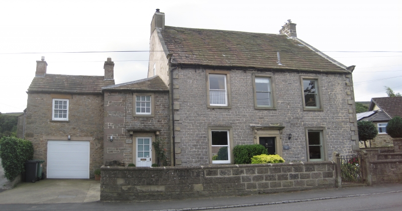
The Hollies East and The Hollies West
(Formerly listed as The Hollins and Hollins House, previously listed as the Hollies)
13/2/67
II
House and cottage. Mid-late C18. Coursed stone with sandstone ashlar dressings, stone slate roof. Two storeys, 1:3 bays.
House to right: raised quoins. Central door of six fielded panels in architrave with frieze and cornice supported on consoles. Sash windows in architraves. Shaped kneelers, ashlar copings, end stacks, that to left in brick.
Cottage to left: lower two-storey range with flush quoins to left. Part-glazed door in plain ashlar surround with projecting slab cornice supported on plain corbels. Above, nine-pane unequally-hung sash window in plain ashlar surround. Hipped roof to left.
Listing NGR: SE0599588397
External links are from the relevant listing authority and, where applicable, Wikidata. Wikidata IDs may be related buildings as well as this specific building. If you want to add or update a link, you will need to do so by editing the Wikidata entry.


Other nearby listed buildings