Latitude: 51.0738 / 51°4'25"N
Longitude: -2.1724 / 2°10'20"W
OS Eastings: 388020
OS Northings: 130514
OS Grid: ST880305
Mapcode National: GBR 1WR.PKP
Mapcode Global: FRA 66B8.X3C
Plus Code: 9C3V3RFH+G3
Entry Name: Unidentified Monument in the Churchyard About 7 Metres South of Porch of Church of St Mary
Listing Date: 9 September 1987
Grade: II
Source: Historic England
Source ID: 1131169
English Heritage Legacy ID: 321115
ID on this website: 101131169
Location: St Mary's Church, East Knoyle, Wiltshire, SP3
County: Wiltshire
Civil Parish: East Knoyle
Built-Up Area: East Knoyle
Traditional County: Wiltshire
Lieutenancy Area (Ceremonial County): Wiltshire
Church of England Parish: East Knoyle St Mary
Church of England Diocese: Salisbury
Tagged with: Monument
EAST KNOYLE CHURCH ROAD
ST 83 SE
(north side)
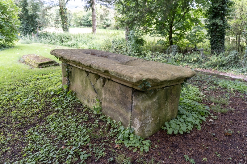
8/9 Unidentified monument in the
churchyard about 7 metres south
of porch of Church of St Mary
GV II
Chest tomb. Mid C18. Limestone tomb with recessed moulded panel
on south side, plain north side, roll-moulded cavetto-moulded flat
top; badly weathered at time of survey (August 1986). Illegible
inscription.
Listing NGR: ST8802030514
External links are from the relevant listing authority and, where applicable, Wikidata. Wikidata IDs may be related buildings as well as this specific building. If you want to add or update a link, you will need to do so by editing the Wikidata entry.


Other nearby listed buildings