Latitude: 53.2138 / 53°12'49"N
Longitude: -1.6763 / 1°40'34"W
OS Eastings: 421715
OS Northings: 368570
OS Grid: SK217685
Mapcode National: GBR 57S.H0S
Mapcode Global: WHCD7.7H13
Plus Code: 9C5W687F+GF
Entry Name: Rutland House
Listing Date: 7 January 1970
Grade: II
Source: Historic England
Source ID: 1132656
English Heritage Legacy ID: 468097
ID on this website: 101132656
Location: Bakewell, Derbyshire Dales, Derbyshire, DE45
County: Derbyshire
District: Derbyshire Dales
Civil Parish: Bakewell
Built-Up Area: Bakewell
Traditional County: Derbyshire
Lieutenancy Area (Ceremonial County): Derbyshire
Church of England Parish: Bakewell All Saints
Church of England Diocese: Derby
Tagged with: House
BAKEWELL
SK2168 BUXTON ROAD 831-1/4/64 (North East side) 07/01/70 Rutland House
GV II
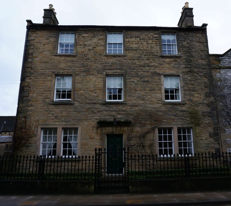
Formerly known as: Rutland House MILL STREET. House. Late C18-early C19. Coursed sandstone facade with ashlar dressings, rubble limestone; Welsh slate, concrete tile and stone slate roofs. EXTERIOR: 3 storeys, 3-window range. Wing to rear left corner and single-storey wing beyond. Symmetrical facade with raised quoins and projecting stone sills to sashes with glazing bars. Central 6-panel door (top 4 panels glazed) in moulded stone architrave with cornice; outer bays have paired sashes in renewed surrounds with stone mullions. Single sashes to each floor above. Plain kneelers to ashlar gable copings; ashlar end stacks with bands. Left return: rear wing projects, small lean-to in angle with main gable. Glazed door beneath full-height stair window consisting of 4 vertically-aligned casements with glazing bars in transomed square-faced surrounds. INTERIOR: not inspected.
Listing NGR: SK2171568570
External links are from the relevant listing authority and, where applicable, Wikidata. Wikidata IDs may be related buildings as well as this specific building. If you want to add or update a link, you will need to do so by editing the Wikidata entry.


Other nearby listed buildings