Latitude: 53.3769 / 53°22'36"N
Longitude: -1.1567 / 1°9'24"W
OS Eastings: 456196
OS Northings: 387007
OS Grid: SK561870
Mapcode National: GBR NYCD.C5
Mapcode Global: WHDDV.6DF0
Plus Code: 9C5W9RGV+Q8
Entry Name: North Farmhouse
Listing Date: 29 July 1966
Last Amended: 15 October 1986
Grade: II
Source: Historic England
Source ID: 1132676
English Heritage Legacy ID: 335801
ID on this website: 101132676
Location: Letwell, Rotherham, South Yorkshire, S81
County: Rotherham
Civil Parish: Letwell
Traditional County: Yorkshire
Lieutenancy Area (Ceremonial County): South Yorkshire
Church of England Parish: Firbeck with Letwell
Church of England Diocese: Sheffield
Tagged with: Farmhouse
LETWELL BARKER HADES ROAD SK58NE (north side) 3/53 No 19 (North Farmhouse) 29.7.66 (formerly listed as House on the eastern corner of the junction of Romper Road with Barker Hades Road)
GV II
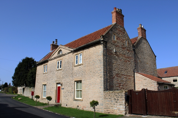
Farmhouse. Late C18-early C19. Squared, coursed rubble limestone, stone slate eaves courses to pantile roof. L-shaped plan with parallel range infilling rear-right angle. 2 storeys with attic, 3 bays. Central 4-panel door with 4-pane overlight in raised ashlar surround with plinth blocks; flanking 4-pane sashes have projecting sills and lintels tooled as voussoirs. 1st floor: three 2-light mullioned windows with projecting sills to square-faced surrounds. Eaves band continues across pedimented central bay which has lunette with radial glazing bars in tympanum. End gables have shaped kneelers, ashlar gable copings and brick end stacks. Left return: two 2-light square-faced mullioned windows in rear wing, 2 single-light windows to attic of front range. Right return: attic windows as left return, gable of rear range with copings and stack as front range.
Listing NGR: SK5619687007
External links are from the relevant listing authority and, where applicable, Wikidata. Wikidata IDs may be related buildings as well as this specific building. If you want to add or update a link, you will need to do so by editing the Wikidata entry.


Other nearby listed buildings