Latitude: 53.8464 / 53°50'47"N
Longitude: -1.86 / 1°51'35"W
OS Eastings: 409308
OS Northings: 438915
OS Grid: SE093389
Mapcode National: GBR HRGY.3X
Mapcode Global: WHC91.DLJ4
Plus Code: 9C5WR4WR+H2
Entry Name: St Ives Mansion House
Listing Date: 9 August 1966
Last Amended: 18 October 1985
Grade: II
Source: Historic England
Source ID: 1133350
English Heritage Legacy ID: 338044
ID on this website: 101133350
BINGLEY ST. IVES ESTATE SE03NE SE093389
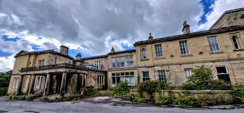
5/180 St. Ives Mansion 9.8.66 House,( formerly listed as St. Ives ) Research Institute and 6 flats)) GV II Large house. Mid-late C19. Dressed stone, blue-slate roofs. 2 storeys. House of complex development: U-shaped with Doric porte-cochere set in centre of wings to rear. Front of 11 bays of differing size. Bays 1 and 2, 7 and 8 project. First 7 bays may be earliest house with projecting 2-bay, 3-storey corner towers. Tall 12-pane sash windows. 7th bay altered C19 when addition to right added which has main feature of oriel to left of carved heraldic shield with same inscription as that over door of Old Harden Grange (q.v.). Lateral stack set above, several other stacks. Right-hand return has 4 bays of sash windows flanked by canted bay windows to each floor. Other stacks.
Interior: Large entrance hall has fluted Ionic columns flanked by pilasters leading to Imperial staircase in Jacobean style. Large fireplace has fluted pilasters surmounted by paired Corinthian columns with stone fireplace with richly-moulded surround. Some heraldic stained glass showing the arms of the Ferrands quartered with various families linked by marriage
Listing NGR: SE0930838915
External links are from the relevant listing authority and, where applicable, Wikidata. Wikidata IDs may be related buildings as well as this specific building. If you want to add or update a link, you will need to do so by editing the Wikidata entry.


Other nearby listed buildings