Approximate Location Map
Large Map »
Latitude: 53.9419 / 53°56'30"N
Longitude: -1.868 / 1°52'4"W
OS Eastings: 408762
OS Northings: 449539
OS Grid: SE087495
Mapcode National: GBR HQDV.CP
Mapcode Global: WHC8N.85QX
Plus Code: 9C5WW4RJ+QR
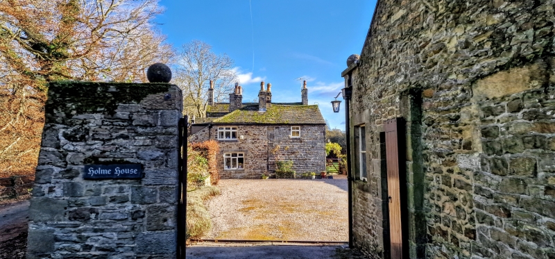
Entry Name: Holme House
Listing Date: 25 January 1985
Grade: II
Source: Historic England
Source ID: 1133425
English Heritage Legacy ID: 337809
ID on this website: 101133425
Location: Low Mill Village, Bradford, West Yorkshire, LS29
County: Bradford
Civil Parish: Addingham
Built-Up Area: Addingham
Traditional County: Yorkshire
Lieutenancy Area (Ceremonial County): West Yorkshire
Church of England Parish: Addingham St Peter
Church of England Diocese: Leeds
Tagged with: House
SE04NE
4/79
ADDINGHAM C P
LOW MILL LANE (south side),
HOLME HOUSE
II
House, the central core of which is an early to mid C18 pair of cottages,with outbuilding range attached to west probably early C19 reusing late C17 or early C18 fabric and early C19 range to the east, altered early C20, forming a U-shaped plan. Hammer-dressed stone, stone slate roof. 2 storeys. Central pair of cottages have paired doorways with dressed jambs with tiestones and deep lintels (one doorway blocked) with 3-light mullioned windows to either side on each floor having flat-faced mullions slightly recessed but with inner chamfer. Gable stacks. Wing breaking forward on left, of watershot stone, has: plinth; quoins; quoined doorway and chamfered lst-floor doorway altered to window; extented to rear. Wing breaking forward on right has east (right) return with plinth, raised quoins, central C20 half-glazed door under 3-pane overlight and lintel withincised keystone, window above door with similar keystone, C20 2-storey bay windows added either side, shaped kneelers, coping and end stacks. Interior: cottage has segmental-arched fireplace with cyma-moulded surround and joggled voussoirs.C20 additions not of special interest. A map of 1817 depicts the building having attained its U-shaped plan.
Listing NGR: SE0876249539
External links are from the relevant listing authority and, where applicable, Wikidata. Wikidata IDs may be related buildings as well as this specific building. If you want to add or update a link, you will need to do so by editing the Wikidata entry.


Other nearby listed buildings
