Approximate Location Map
Large Map »
Latitude: 53.9114 / 53°54'41"N
Longitude: -1.7417 / 1°44'30"W
OS Eastings: 417062
OS Northings: 446170
OS Grid: SE170461
Mapcode National: GBR JR86.QM
Mapcode Global: WHC8Q.6YVB
Plus Code: 9C5WW765+H8
Entry Name: Chevin House and Highway Cottage
Listing Date: 18 July 1949
Last Amended: 20 May 1976
Grade: II
Source: Historic England
Source ID: 1133483
English Heritage Legacy ID: 337652
ID on this website: 101133483
Location: Burley in Wharfedale, Bradford, West Yorkshire, LS29
County: Bradford
Civil Parish: Burley
Built-Up Area: Burley in Wharfedale
Traditional County: Yorkshire
Lieutenancy Area (Ceremonial County): West Yorkshire
Church of England Parish: Burley-in-Wharfedale St Mary the Blessed Virgin
Church of England Diocese: Leeds
Tagged with: Cottage
This list entry was subject to a Minor Amendment on 26 May 2023 to update the group value statement and to reformat the text to current standards
SE 1746
8/22A
Burley in Wharfedale
MAIN STREET (North Side) LS29 7DT
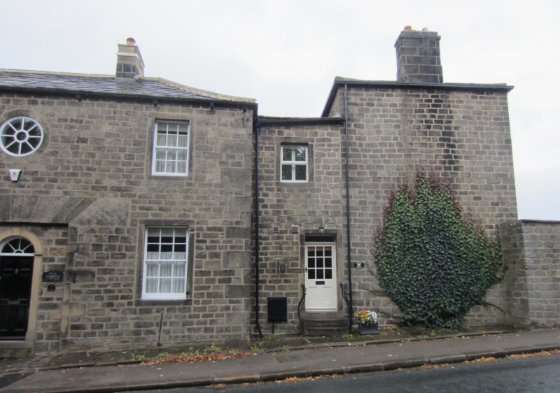
No 2 (Highway Cottage) and Chevin House
(Formerly listed as No 2 (Chevin House and Highway Cottage) previously listed as Former Stables of Burley Lodge, Otley Road, Burley in Wharfedale)
18.7.49.
GV
II
C18. Abutting the lodge at right angles, facing the road. Two storeys. Coursed rubble. Small, wide-spaced gutter brackets. Hipped stone slab roof. Symmetrical. Three windows; the side ones sashes (the top right modern, the others with glazing bars, those on the left with ears); the upper central one circular; below it a doorway with flat head, but now blocked with window on left. Doorway in right hand extension has overlight with patterned glazing bars (now part of Chevin House).
Burley Lodge, No 2 (Highway Cottage) and Chevin House, Nos 4 to 16 (even), Nos 24 to 30 (even) and 30A, 2 Post Office Yard, St Mary's Church, wall around ground south of mill pond (along Main Street and west side of Corn Mill Lane), and the Malt Shovel Hotel, form a group.
Listing NGR: SE1706246170
External links are from the relevant listing authority and, where applicable, Wikidata. Wikidata IDs may be related buildings as well as this specific building. If you want to add or update a link, you will need to do so by editing the Wikidata entry.


Other nearby listed buildings
