Latitude: 53.7086 / 53°42'30"N
Longitude: -1.9115 / 1°54'41"W
OS Eastings: 405936
OS Northings: 423579
OS Grid: SE059235
Mapcode National: GBR HT2K.Y9
Mapcode Global: WHB8N.L1YR
Plus Code: 9C5WP35Q+C9
Entry Name: 11, 13 and 15, Town Hall Street
Listing Date: 19 July 1988
Grade: II
Source: Historic England
Source ID: 1134461
English Heritage Legacy ID: 339414
ID on this website: 101134461
Location: Friendly, Calderdale, West Yorkshire, HX6
County: Calderdale
Electoral Ward/Division: Sowerby Bridge
Parish: Non Civil Parish
Built-Up Area: Halifax
Traditional County: Yorkshire
Lieutenancy Area (Ceremonial County): West Yorkshire
Church of England Parish: Sowerby Bridge Christ Church
Church of England Diocese: Leeds
Tagged with: Architectural structure
This list entry was subjected to a Minor Enhancement 11 June 2024 to amend details in the description, add Historical Note and Sources
SE 0423 and SE 0523
12/282
SOWERBY BRIDGE
TOWN HALL STREET (north side)
Nos 11, 13 and 15
(Formerly listed as Nos 11 (Doreens ), No 13 (Lyns) and No 15 (Village Gossip)
GV
II
Row of three shops, built by 1866, but frontage appearing late C19.
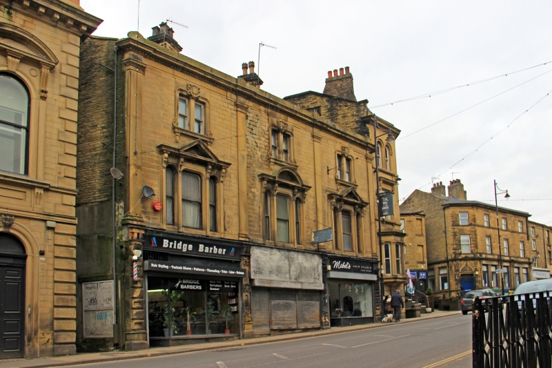
Built of stone ashlar with a slate roof, with a three-storey, three-bay frontage. The ground floor of the building has rusticated quoins, the bays being divided by panelled pilasters. Extending above all these are giant Classical strip pilasters which extend to support an eves band and dentilled cornice forming an entablature with a blocking course above. The first-floor windows are tripartite with narrower, round arched sidelights. The lights are fitted with sashes. They are divided and flanked by pilasters with consoles supporting cornices. These cornices support pediments above the central lights, that to the middle window being segmental, the flanking windows having triangular pediments. The second-floor windows are each of two lights set within an architrave with shield-and-foliage-decorated keystones, the window cills being supported on consoles. The front roof slope retains two chimney stacks that are corniced and set at an angle.
Listing NGR: SE0593623579
Although the style of the frontage appears to be late C19 this appears to be a refronting of an earlier building depicted on Local Board plans dated 1866 which shows the western shop (11 Town Hall Street) labelled as the post office. By the 1888 Ordnance Survey Town Plan the post office had moved to other premises. In 1920 the London Joint City and Midland Bank applied for permission to convert 13 and 15 into a bank with the construction of a strong room in the basement, the 1:2500 Ordnance Survey map surveyed 1931 marking the building as ‘Bk’.
External links are from the relevant listing authority and, where applicable, Wikidata. Wikidata IDs may be related buildings as well as this specific building. If you want to add or update a link, you will need to do so by editing the Wikidata entry.


Other nearby listed buildings