Approximate Location Map
Large Map »
Latitude: 53.5746 / 53°34'28"N
Longitude: -1.7263 / 1°43'34"W
OS Eastings: 418218
OS Northings: 408699
OS Grid: SE182086
Mapcode National: GBR JWD3.1B
Mapcode Global: WHCBG.GF50
Plus Code: 9C5WH7FF+RF
Entry Name: Ward Boundary Post Opposite Marsh Lane Top
Listing Date: 4 August 1983
Grade: II
Source: Historic England
Source ID: 1134804
English Heritage Legacy ID: 340488
ID on this website: 101134804
Location: Gate Foot, Kirklees, West Yorkshire, HD8
County: Kirklees
Civil Parish: Kirkburton
Traditional County: Yorkshire
Lieutenancy Area (Ceremonial County): West Yorkshire
Church of England Parish: Shepley St Paul
Church of England Diocese: Leeds
Tagged with: Architectural structure Boundary marker
SE 10 NE PENISTONE ROAD
5/261 (Lane Head)
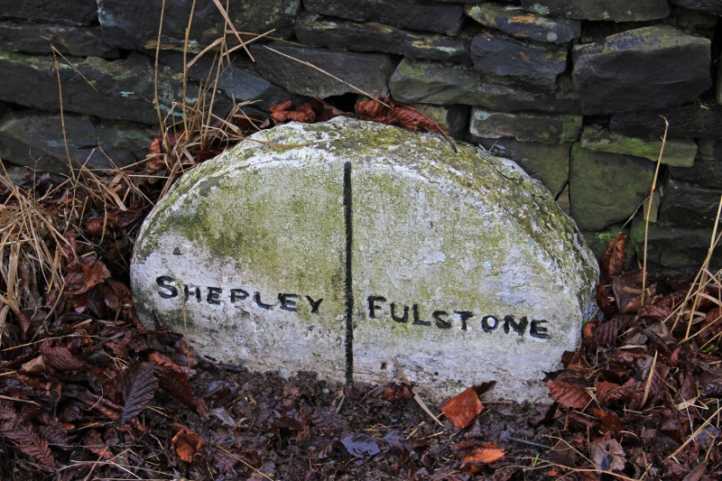
Ward boundary post
opposite Marsh Lane
Top
II
Stone post with rounded top. Mid C19. Inscribed:
FULSTONE SHEPLEY
Listing NGR: SE1821808699
External links are from the relevant listing authority and, where applicable, Wikidata. Wikidata IDs may be related buildings as well as this specific building. If you want to add or update a link, you will need to do so by editing the Wikidata entry.


Other nearby listed buildings
