Approximate Location Map
Large Map »
Latitude: 53.5631 / 53°33'47"N
Longitude: -1.7534 / 1°45'12"W
OS Eastings: 416429
OS Northings: 407419
OS Grid: SE164074
Mapcode National: GBR JW67.5F
Mapcode Global: WHCBG.1P9S
Plus Code: 9C5WH67W+7J
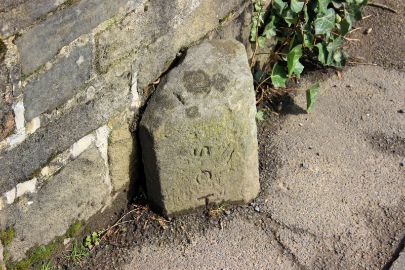
Entry Name: Ward Boundary Stone on Bridge over Jackson Bridge Dike
Listing Date: 4 August 1983
Grade: II
Source: Historic England
Source ID: 1134814
English Heritage Legacy ID: 340510
ID on this website: 101134814
Location: Jackson Bridge, Kirklees, West Yorkshire, HD9
County: Kirklees
Civil Parish: Holme Valley
Built-Up Area: Scholes
Traditional County: Yorkshire
Lieutenancy Area (Ceremonial County): West Yorkshire
Church of England Parish: New Mill Christ Church
Church of England Diocese: Leeds
Tagged with: Architectural structure
SE 10 NE SCHOLES ROAD
5/283 (Jackson Bridge)
Ward Boundary Stone on
Bridge over Jackson
Bridge Dkie
II
Ward boundary stone. Mid-late C19. Triangular stone post with inscription.
SCHOLES HEPWORTH. Badly worn and part buried.
Listing NGR: SE1642907419
External links are from the relevant listing authority and, where applicable, Wikidata. Wikidata IDs may be related buildings as well as this specific building. If you want to add or update a link, you will need to do so by editing the Wikidata entry.


Other nearby listed buildings
