Approximate Location Map
Large Map »
Latitude: 53.5634 / 53°33'48"N
Longitude: -1.7523 / 1°45'8"W
OS Eastings: 416505
OS Northings: 407454
OS Grid: SE165074
Mapcode National: GBR JW67.FB
Mapcode Global: WHCBG.1PVK
Plus Code: 9C5WH67X+93
Entry Name: 9, East Street
Listing Date: 4 August 1983
Grade: II
Source: Historic England
Source ID: 1313544
English Heritage Legacy ID: 340313
ID on this website: 101313544
Location: Jackson Bridge, Kirklees, West Yorkshire, HD9
County: Kirklees
Civil Parish: Holme Valley
Built-Up Area: Scholes
Traditional County: Yorkshire
Lieutenancy Area (Ceremonial County): West Yorkshire
Church of England Parish: New Mill Christ Church
Church of England Diocese: Leeds
Tagged with: Building
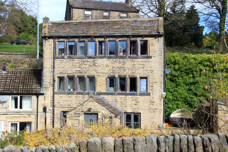
SE 10 NE EAST STREET
5/86 (Jackson Bridge)
No 9
II
Weaver's house. Early to mid C19 with alterations. Hammer dressed stone.
Stone slate roof. Three storeys. Central doorway with sash to left and
right. First and second floors each have one 9-light stone mullioned
window, with blocked centre light to first floor.
Listing NGR: SE1650507453
External links are from the relevant listing authority and, where applicable, Wikidata. Wikidata IDs may be related buildings as well as this specific building. If you want to add or update a link, you will need to do so by editing the Wikidata entry.


Other nearby listed buildings
