Latitude: 53.7581 / 53°45'28"N
Longitude: -1.4465 / 1°26'47"W
OS Eastings: 436589
OS Northings: 429219
OS Grid: SE365292
Mapcode National: GBR LSBZ.ML
Mapcode Global: WHDBR.RSCW
Plus Code: 9C5WQH53+69
Entry Name: Church of All Saints
Listing Date: 28 March 1988
Grade: II
Source: Historic England
Source ID: 1135650
English Heritage Legacy ID: 342120
Also known as: Church of All Saints, Woodlesford
ID on this website: 101135650
Location: Woodlesford, Leeds, West Yorkshire, LS26
County: Leeds
Electoral Ward/Division: Rothwell
Parish: Non Civil Parish
Built-Up Area: Rothwell
Traditional County: Yorkshire
Lieutenancy Area (Ceremonial County): West Yorkshire
Church of England Parish: Oulton with Woodlesford St John
Church of England Diocese: Leeds
Tagged with: Church building
SE 32 NE ROTHWELL STATION LANE LS26 (north side) Woodlesford
6/109 Church of All Saints
II
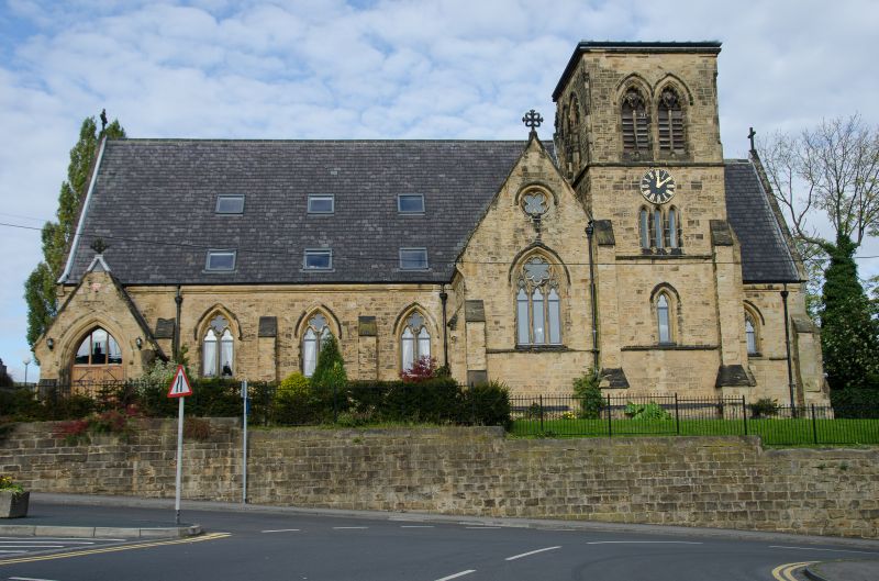
Church. 1870, by Perkin and Sons (Batty History of Rothwell, 1877, p.xii). Furrowed sandstone, slate roof. Early English style. Nave with south transept, chancel with south tower and spire. Buttressed 4-bay nave has gabled porch to 1st bay, with moulded 2-centred arched doorway, steeply- pitched roof with stone copings and apex cross; three 2-centred arched windows each of 2 trefoil lights with a quatrefoil in the head, and hoodmould; west gable has 3 lancets and a cinquefoil above, stone coping and apex cross to steeply-pitched roof. Transept has angle buttresses, large 3-light window with a multifoil in the head. Three stage tower, with angle- buttresses, has cusped single-light window to ist stage, triple lancets to the 2nd stage, large coupled belfry windows each with a colonette and 2 cusped lights with a multifoil in the head, a parapet pierced with trefoils, and a broach spire with lucarnes in the cardinal sides and a ball finial bearing a weathervane; semicircular stairturret in the angle with the chancel. East window of 4 cusped lights with 3 quatrefoils in the head. Interior not inspected.
Listing NGR: SE3658929219
External links are from the relevant listing authority and, where applicable, Wikidata. Wikidata IDs may be related buildings as well as this specific building. If you want to add or update a link, you will need to do so by editing the Wikidata entry.


Other nearby listed buildings