Approximate Location Map
Large Map »
Latitude: 50.6042 / 50°36'15"N
Longitude: -4.5124 / 4°30'44"W
OS Eastings: 222311
OS Northings: 81293
OS Grid: SX223812
Mapcode National: GBR NC.CBRJ
Mapcode Global: FRA 17FG.PWB
Plus Code: 9C2QJF3Q+M2
Entry Name: Altarnun Old Bridge
Listing Date: 23 November 1988
Last Amended: 18 October 2017
Grade: II
Source: Historic England
Source ID: 1138194
English Heritage Legacy ID: 68275
ID on this website: 101138194
Location: Altarnun, Cornwall, PL15
County: Cornwall
Civil Parish: Altarnun
Traditional County: Cornwall
Lieutenancy Area (Ceremonial County): Cornwall
Church of England Parish: Altarnon with Bolventor
Church of England Diocese: Truro
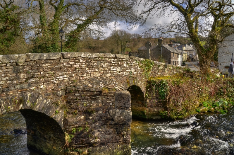
Bridge, possibly late medieval, but perhaps later. Widened in the early C20; original width re-instated and bridge restored in 1970s.
Bridge, possibly late medieval, but perhaps later. Widened in the early C20; original width re-instated and bridge restored in 1970s.
MATERIALS: constructed of slatestone rubble with roughly-dressed stone arches and granite coping to the parapets.
DESCRIPTION: the bridge crosses the Penpont Water within the village of Altarnun. It is constructed of slatestone rubble and granite coping stones to the parapets. It comprises two semi-circular arches and a central pier, which has full-height, pointed cutwaters to both the down and upstream sides. These probably originally continued up to the parapets to form refuges, but have since been truncated and capped with concrete at the level of the parapet base to each side. The south-east abutment projects asymmetrically to each side beneath the parapet, extending along the sloping riverbank on either side. The walls facing the north-western abutment converge at an angle to each face of the bridge and are largely rebuilt on the downstream side, but the rest of this abutment is largely contained within the much steeper riverbank on that side and masked beneath a road. The parapets are also built of slatestone rubble with iron-tied granite coping to the downstream side. They curve outwards at the ends; the downstream parapet at the north-west end extends along the riverbank though much of this section represents a lower and broader rebuild with a capping of slate slabs.
Altarnun Old Bridge spans the Penpont Water, a tributary of the River Inney, and provides access between the area of the village called Penpont to the south-east of the river and the parish Church of St Nonna (Grade I) to the north-west. Although it is a minor route, the road that the bridge spans is of considerable antiquity, as attested by several medieval wayside crosses along its course. The precise date of the bridge is uncertain. The historian, Charles Henderson (see SOURCES) attributes a C15 date, though it may possibly be post medieval, with medieval origins.
In 1928 Henderson described the carriageway of the bridge as having been recently widened slightly on the downstream (east) side to accommodate motor vehicles. As part of this work, iron girders were inserted along this side of the bridge to support the parapet which was realigned. In the 1970s a new road bridge was constructed at a former fording point adjacent to the existing bridge, and Altarnun Old Bridge was restored to its original width and the downstream parapet was rebuilt.
Altarnun Old Bridge is listed at Grade II for the following principal reasons:
Architectural interest:
* It is a good survival of a probable late-medieval bridge which, despite later alteration and subsequent restoration, retains the majority of its early fabric;
* It is a neatly-made structure with well-constructed, semi-circular arches to the spans.
Historic interest:
* It forms part of a historic route and has connected local parishioners with the Church of St Nonna for many centuries.
External links are from the relevant listing authority and, where applicable, Wikidata. Wikidata IDs may be related buildings as well as this specific building. If you want to add or update a link, you will need to do so by editing the Wikidata entry.


Other nearby listed buildings
