Approximate Location Map
Large Map »
Latitude: 53.1108 / 53°6'39"N
Longitude: -2.5842 / 2°35'2"W
OS Eastings: 360993
OS Northings: 357232
OS Grid: SJ609572
Mapcode National: GBR 7Q.82SB
Mapcode Global: WH9B3.82PH
Plus Code: 9C5V4C68+88
Entry Name: Wardle Pinfold
Listing Date: 3 August 1984
Grade: II
Source: Historic England
Source ID: 1138609
English Heritage Legacy ID: 56837
ID on this website: 101138609
Location: Wardle, Cheshire East, Cheshire, CW5
County: Cheshire East
Civil Parish: Wardle
Traditional County: Cheshire
Lieutenancy Area (Ceremonial County): Cheshire
Church of England Parish: Bunbury St Boniface
Church of England Diocese: Chester
Tagged with: Architectural structure Animal pound
SJ 65 NW WARDLE C.P. WARDLE
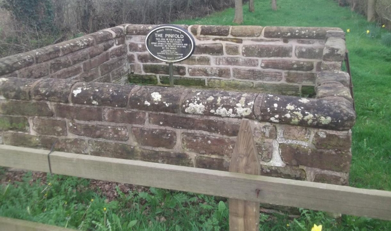
3/78 Wardle Pinfold
II
Cattle pound, early C19, restored 1981. Of red sandstone blocks 4.2m
square and 1.2m high in coursed rubble. The compound has a metal
gated opening on the west side. The wall is topped by a roughly
rounded stone coping.
Listing NGR: SJ6099357232
External links are from the relevant listing authority and, where applicable, Wikidata. Wikidata IDs may be related buildings as well as this specific building. If you want to add or update a link, you will need to do so by editing the Wikidata entry.


Other nearby listed buildings
