Latitude: 54.5869 / 54°35'12"N
Longitude: -1.0825 / 1°4'56"W
OS Eastings: 459392
OS Northings: 521682
OS Grid: NZ593216
Mapcode National: GBR NHWD.FJ
Mapcode Global: WHF80.BZS0
Plus Code: 9C6WHWP9+P2
Entry Name: Boundary Walls and Transverse Wall Enclosing Former Kirkleatham Gardens
Listing Date: 12 June 1973
Grade: II
Source: Historic England
Source ID: 1139643
English Heritage Legacy ID: 60323
ID on this website: 101139643
Location: Kirkleatham, Redcar and Cleveland, North Yorkshire, TS11
County: Redcar and Cleveland
Electoral Ward/Division: Dormanstown
Parish: Non Civil Parish
Traditional County: Yorkshire
Lieutenancy Area (Ceremonial County): North Yorkshire
Church of England Parish: Kirkleatham
Church of England Diocese: York
Tagged with: Wall
REDCAR KIRKLEATHAM
NZ 52 SE
4/67 Boundary walls and
transverse wall enclosing
12.6.73
former Kirkleatham Gardens
G.V. II
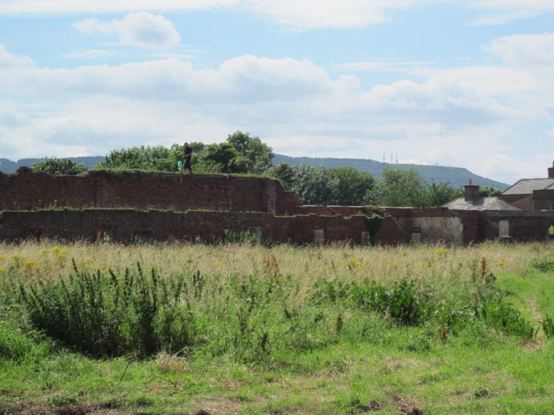
Boundary walls and transverse wall of former kitchen gardens, mid/late C17.
North wall partly rebuilt and raised in C18, and east end partly rebuilt in
late C20. West wall raised by 2 courses, and middle section partly rebuilt
mid/late C19. South wall rebuilt mid/late C18, south side refaced mid/late
C19; mid C19 short return at west end. Middle wall partly rebuilt mid/late
C18 and at west end mid/late C19. Brick, with stone dressings to gatepiers
and flat stone and concrete copings. High north wall has pilaster strips on
north face. Blocked central entrance has gatepiers, each with moulded
plinth, cornice and cap; strengthened with additional brickwork on inner
face; finials missing. Slightly-projecting side entrance, with blocked
round-headed opening, at west end; matching entrance at east end, rebuilt
late C20, with plain piers and renewed timber double gates; finials missing.
Lower east and west walls have pilaster strips on outer faces. East wall
has no coping; several upper courses missing at south end ; demolished
section south of house. South wall has 3 round-headed openings; several
copings missing; raked down to lower west wall. Was heated wall and retains
3 square-ended iron shafts (for control handles) in stone surrounds in north
face, west of middle opening; probably used to control dampers, etc., in
core of wall. Middle wall raked down to lower west wall at west of
round-headed opening. East end demolished. Copings mostly missing.
Remains of bothies adjoining north face of middle wall and remains of house
and walls adjacent to east wall, are too ruinous to be of special interest.
Gardens disused and walls dilapidated at time of resurvey.
Listing NGR: NZ5939221682
External links are from the relevant listing authority and, where applicable, Wikidata. Wikidata IDs may be related buildings as well as this specific building. If you want to add or update a link, you will need to do so by editing the Wikidata entry.


Other nearby listed buildings