Latitude: 54.5879 / 54°35'16"N
Longitude: -1.0768 / 1°4'36"W
OS Eastings: 459760
OS Northings: 521807
OS Grid: NZ597218
Mapcode National: GBR NHXD.P4
Mapcode Global: WHF80.FYH6
Plus Code: 9C6WHWQF+57
Entry Name: Boundary Wall Ha-Ha Wall Gates and Gatepiers to South of Kirkleatham Hall School
Listing Date: 29 April 1988
Grade: II
Source: Historic England
Source ID: 1139645
English Heritage Legacy ID: 60331
ID on this website: 101139645
Location: Kirkleatham, Redcar and Cleveland, North Yorkshire, TS11
County: Redcar and Cleveland
Electoral Ward/Division: Dormanstown
Parish: Non Civil Parish
Traditional County: Yorkshire
Lieutenancy Area (Ceremonial County): North Yorkshire
Church of England Parish: Kirkleatham
Church of England Diocese: York
Tagged with: Wall
REDCAR KIRKLEATHAM
NZ 52 SE and NZ 62 SW
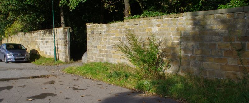
4/75 Boundary wall, ha-ha wall,
gates and gatepiers to
south of Kirkleatham
Hall School.
G.V. II.
Ha-Ha wall, mid/late C18; boundary wall c.1800; and gates and gatepiers
1919; on southern boundary of grounds of Kirkleatham Hall School and
Washaways Plantation. Dressed sandstone; ashlar gatepiers and flanking
parts of wall; iron gates. Ha-ha wall runs for c.210m. alongside stream,
and is ramped up at east end, to high boundary wall of Washaways Plantation,
which curves gently to north-east, running for c.350m, terminating in gates
and gatepiers. Walls have flat copings. Banded rusticated gatepiers, each
with narrow cornice under short pedestal with heavily-moulded cornice and
ball finial. 2-leaf gates, segment-headed when closed. Each leaf has
dograil of arrowheads, scrolled panel of double lockrail supporting
waterleaf ornament and verticals alternately turned. Scrolled mock
overthrow and crestings. Ha-ha wall formerly fronted grounds of Kirkleatham
Hall (demolished 1955) and gates and gatepiers formed entrance to driveway
leading to the Hall. Gates dilapidated at time of resuvey. Included for
group value and as integral with layout of grounds of Kirkleatham Hall and
Stable Block (Kirkleatham Hall Farm, q.v.).
Listing NGR: NZ5976021807
External links are from the relevant listing authority and, where applicable, Wikidata. Wikidata IDs may be related buildings as well as this specific building. If you want to add or update a link, you will need to do so by editing the Wikidata entry.


Other nearby listed buildings