Latitude: 54.5897 / 54°35'23"N
Longitude: -1.0791 / 1°4'44"W
OS Eastings: 459604
OS Northings: 522006
OS Grid: NZ596220
Mapcode National: GBR NHXC.5H
Mapcode Global: WHF80.DWCT
Plus Code: 9C6WHWQC+V8
Entry Name: Gatehouse 120 Metres North East of Kirkleatham Hall Farm
Listing Date: 23 June 1952
Last Amended: 29 April 1988
Grade: II*
Source: Historic England
Source ID: 1160114
English Heritage Legacy ID: 60328
ID on this website: 101160114
Location: Kirkleatham, Redcar and Cleveland, North Yorkshire, TS10
County: Redcar and Cleveland
Electoral Ward/Division: Dormanstown
Parish: Non Civil Parish
Traditional County: Yorkshire
Lieutenancy Area (Ceremonial County): North Yorkshire
Church of England Parish: Kirkleatham
Church of England Diocese: York
Tagged with: Gatehouse
REDCAR KIRKLEATHAM NZ 52 SE 4/72 Gatehouse, 120m north-east of Kirkleatham Hall Farm 23.6.52 (formerly listed as Kirkleatham Hall archway) G.V. II*
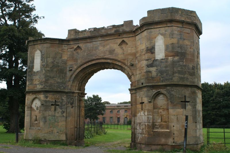
Ornamental gatehouse, c.1780, possibly by John Carr. Dressed sandstone with brick inner leaf to towers. Roofs missing. Gothick style. 2 octagonal 2-storey towers linked by bridge, form elliptical-headed opening with archivolt and roll-moulded imposts continued as string courses. West face of each tower has blocked pointed chamfered doorway under hoodmould, and blocked cusped ogee-headed window on first floor. Blind cross-arrowloops on ground floor of flanking faces. Bridge has blind quatrefoils in lozenge-shaped panels. Continuous coved cornice and embattled parapet, merlons and embrasures now partly missing. Returns have arrowloops on first floor. East face: similar to west face but with blind windows, holding blocked trefoil openings in tympana, on ground floor. Imitation cannon barrels project from square spandrel panels of hollow-chamfered, roll-moulded central opening, with inner moulded order in head of arch. Interior: north tower has remains of newel stair. South tower has remains of vaulted ceiling to ground-floor chamber. Disused and dilapidated at time of resurvey. N.M.R. photograph: AA53/12863: 1953. On former driveway to Kirkleatham Hall, demolished 1955.
Listing NGR: NZ5960422006
External links are from the relevant listing authority and, where applicable, Wikidata. Wikidata IDs may be related buildings as well as this specific building. If you want to add or update a link, you will need to do so by editing the Wikidata entry.


Other nearby listed buildings