Approximate Location Map
Large Map »
Latitude: 52.2445 / 52°14'40"N
Longitude: 0.7123 / 0°42'44"E
OS Eastings: 585268
OS Northings: 264165
OS Grid: TL852641
Mapcode National: GBR QF0.6WS
Mapcode Global: VHKD4.9VD8
Plus Code: 9F426PV6+QW
Entry Name: 60, Abbeygate Street
Listing Date: 11 February 1987
Last Amended: 30 October 1997
Grade: II
Source: Historic England
Source ID: 1141149
English Heritage Legacy ID: 466618
ID on this website: 101141149
Location: Bury St Edmunds, West Suffolk, IP33
County: Suffolk
District: West Suffolk
Civil Parish: Bury St Edmunds
Built-Up Area: Bury St Edmunds
Traditional County: Suffolk
Lieutenancy Area (Ceremonial County): Suffolk
Church of England Parish: Bury St Edmunds St Mary
Church of England Diocese: St.Edmundsbury and Ipswich
Tagged with: Building
BURY ST EDMUNDS
TL8564SW ABBEYGATE STREET
639-1/14/156 (South side)
11/02/87 No.60
(Formerly Listed as:
ABBEYGATE STREET
No.60
Alliance Building Society)
GV II
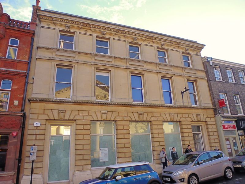
Offices, formerly bank. 1868, by John Gibson. Fine ashlared
facade in Ancaster stone with a base of Portland stone;
parapeted roof.
EXTERIOR: 3 storeys, 5 bays. High Victorian Italianate style.
Rusticated ground floor has 5 openings divided by piers with
keystoned flat arches. All windows replaced, but openings
undamaged. First and second floors have 5 original plate glass
sashes in deep reveals with moulded raised architrave
surrounds. First floor has criss-cross string course, second
floor fluted and then foliated plat-bands. Ornate keystones to
second floor architraves, projecting cornice with mutules,
roundels and dentils, all boldly detailed and deliberately
varied in contrasting scales.
INTERIOR: not inspected.
(BOE: Pevsner N: Radcliffe E: Suffolk: London: 1974-: 149).
Listing NGR: TL8526864165
External links are from the relevant listing authority and, where applicable, Wikidata. Wikidata IDs may be related buildings as well as this specific building. If you want to add or update a link, you will need to do so by editing the Wikidata entry.


Other nearby listed buildings
